Approximate Location Map
Large Map »
Latitude: 50.3576 / 50°21'27"N
Longitude: -4.2698 / 4°16'11"W
OS Eastings: 238640
OS Northings: 53319
OS Grid: SX386533
Mapcode National: GBR NQ.VT85
Mapcode Global: FRA 18Y3.2DP
Plus Code: 9C2Q9P5J+23
Entry Name: Tregantle Fort
Listing Date: 26 January 1987
Grade: II
Source: Historic England
Source ID: 1159255
English Heritage Legacy ID: 61671
ID on this website: 101159255
Location: Cornwall, PL11
County: Cornwall
Civil Parish: Antony
Traditional County: Cornwall
Lieutenancy Area (Ceremonial County): Cornwall
Church of England Parish: Antony
Church of England Diocese: Truro
Tagged with: Fort
SX 35 SE ANTONY
5/16 Tregantle Fort
II
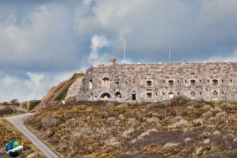
Fort. 1865. Snecked rockfaced limestone rubble with stone dressings. Irregular 6-
sided plan, with gatehouse to south east, keep to east, barrack blocks along south
and 3 caponiers facing west. The principal armament was smooth bore breech-loading
32-pounders.
The gatehouse has round-arched entrance with rockfaced banded rustication with
keystone and latern overthrow, lettering: TREGANTLE FORT, double panelled studded
doors. Bull nose moulding stepped up over parapet over archway with 2 blind recessed
shields. Gatehouse has quadripartite brick vaulting with door to right and left to
vaulted chambers. Inner archway is plain, round-headed, in granite, with circular
stone sentry-box to right with round-arched opening and squint lancet to each side.
EVII letter box set in wall to left. To left of gatehouse, 7 bays with round arches
in stonework, each arch over a segmental-headed gun casement with lancet to each side
and horizontal opening over; bull nose moulding continued over, with brick parapet
and 7 stacks heating barrack blocks. 2-storey ravelin to left end, with 2 gun
casements to side at ground and first floor level, one to front. To right of
gatehouse, the outer side of the keep has wall ramped up to right and left, with 8
similar round arches in stonework with similar openings, and at upper level, 5
segmental-headed gun casements. Walls to right built up with earthworks. Inside the
fort, along the south east range, 6 bays of barrack blocks with round arches
recessed, over door with 12-pane sash to each side. Along the southern range, the
blocks are splayed, of 3 bays and 8 bays. 3-bay range has round arches, with 24-pane
sashes at first floor and doors and 12-pane sashes at ground floor, some blocked.
Main barrack range of 8 bays has round arches, each over 3 sashes, each over 3 sashes
at first floor, with cill band course and upper band course, central rectangular
opening over sashes; ground floor has central door with overlight and sash to each
side in each bay. Parapet and coping with stack to each bay. 2 windows at each end
without arches over, and door to each end. This range is splayed back to right end
with one and 4 similar bays, than parapet steps down to lower 1½ storey range with 3
and 6 bays of round arhces, doors and sashes, leading up to south west caponier. The
keep, to the east side, is semi-circular fronted facing inwards, of 2 storeys. The
keep has round arches, each over triplet opening, large to centre with lancet to each
side, with horizontal opening over. Bull nose moulding over and 12 bays above each
with central casement with segmental head and keystone; 3rd bay from east has
segmental-headed doorway with stepped head, granite voussoirs and keystone. Sockets
remain for drawbridge over ditch, now fixed bridge. Railings along ditch parapet
wall.
Inside the fort, intersections of roads have piers on chamfered plinths, with flat
top and carved raised crests of regiments.
To north west, 2 circular gun emplacements with brick vaulted roofs, shackles to
sides and metal circular gun pivot tracks. The parapet is stepped up over these. 3
raised caponiers to west.
In 1859, A commisson was formed by Palmerston, "to consider the Defences of the
United Kingdom", after the pressure of public opinion following the news that the
French Navy were building iron-clad warships. The design of the forts was in the
hands of the Royal engineers, in the person of Colonel, later Lt. General, Sir W.F.
Drummond Jarvis RE. Tregantle Fort was one of the outer line of forts defending
Plymouth. The estimated cost was £189999, but on completion in 1865, the final cost
was found to be £189119. The fort was designed for 35 guns, (12 to bear upon the
front), excluding the lighter guns for the defence of the ditch. Situated roughly
360 feet above sea level, with ditches on the east, north and west sides, reverted
scarps and counterscarps flanked by the western caponiers, Tregantle commanded a very
extensive view. The total number of guns at Tregantle was 87. In 1866, Coast
Bridgate RA quartered a regular element at Tregantle. In 1882 it was manned by the
Garrison Artillery Coast Bridge with only 6 other ranks. From 1900 to 1903, the
Infantry Battalion were headquartered there and the unit consisted of 14 officers and
423 other ranks. From 1903, the ranges were used for musketry training. (Sources:
Rawlings, K.J.: Defence Works Plymouth Area 1300-1983. 1984)
Listing NGR: SX3864053319
External links are from the relevant listing authority and, where applicable, Wikidata. Wikidata IDs may be related buildings as well as this specific building. If you want to add or update a link, you will need to do so by editing the Wikidata entry.


Other nearby listed buildings
