Approximate Location Map
Large Map »
Latitude: 51.6152 / 51°36'54"N
Longitude: -0.2252 / 0°13'30"W
OS Eastings: 522979
OS Northings: 192201
OS Grid: TQ229922
Mapcode National: GBR B6.V72
Mapcode Global: VHGQC.1NTN
Plus Code: 9C3XJQ8F+3W
Entry Name: The Mount School
Listing Date: 7 April 1983
Grade: II
Source: Historic England
Source ID: 1191702
English Heritage Legacy ID: 199006
Also known as: The Mount
Parkfield
ID on this website: 101191702
Location: Mill Hill, Barnet, London, NW7
County: London
District: Barnet
Electoral Ward/Division: Mill Hill
Parish: Non Civil Parish
Built-Up Area: Barnet
Traditional County: Middlesex
Lieutenancy Area (Ceremonial County): Greater London
Church of England Parish: St Paul Mill Hill
Church of England Diocese: London
Tagged with: House School building
1.
5004
TQ 2292
17/45
MILESPIT HILL
Mill Hill NW7
The Mount School
II
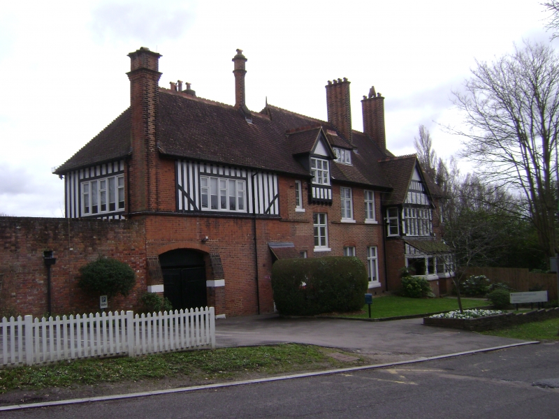
2.
By T E Colcutt. Circa 1875. Large house of picturesque design. Two storeys with
dormers within a tiled roof. Red brick with timbered gables and rendered infil panels.
High prominent chimneys.
Listing NGR: TQ2297992201
External links are from the relevant listing authority and, where applicable, Wikidata. Wikidata IDs may be related buildings as well as this specific building. If you want to add or update a link, you will need to do so by editing the Wikidata entry.


Other nearby listed buildings
