Approximate Location Map
Large Map »
Latitude: 51.5481 / 51°32'53"N
Longitude: -1.1472 / 1°8'50"W
OS Eastings: 459227
OS Northings: 183586
OS Grid: SU592835
Mapcode National: GBR 91L.YKF
Mapcode Global: VHCYW.2CC3
Plus Code: 9C3WGVX3+64
Entry Name: Wall to the Great House Meadow
Listing Date: 9 April 1952
Last Amended: 13 January 1986
Grade: II
Source: Historic England
Source ID: 1193817
English Heritage Legacy ID: 248002
ID on this website: 101193817
Location: Moulsford, South Oxfordshire, OX10
County: Oxfordshire
District: South Oxfordshire
Civil Parish: Moulsford
Built-Up Area: Moulsford
Traditional County: Berkshire
Lieutenancy Area (Ceremonial County): Oxfordshire
Tagged with: Wall
MOULSFORD FERRY LANE
SU5983 (North side)
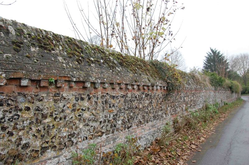
10/118 Wall to the Great House
09/04/52 Meadow
(Formerly listed as wall to
the Great Meadow
GV II
Wall. Probably early C18. Knapped flint panels with red brick dressings; dentil
course to top, angled brick coping.
Listing NGR: SU5922783586
External links are from the relevant listing authority and, where applicable, Wikidata. Wikidata IDs may be related buildings as well as this specific building. If you want to add or update a link, you will need to do so by editing the Wikidata entry.


Other nearby listed buildings
