Approximate Location Map
Large Map »
Latitude: 51.4558 / 51°27'20"N
Longitude: -2.5813 / 2°34'52"W
OS Eastings: 359708
OS Northings: 173137
OS Grid: ST597731
Mapcode National: GBR CCJ.4Z
Mapcode Global: VH88N.6NRW
Plus Code: 9C3VFC49+8F
Entry Name: Kingsley Hall
Listing Date: 8 January 1959
Grade: II*
Source: Historic England
Source ID: 1207565
English Heritage Legacy ID: 380059
ID on this website: 101207565
Location: Newtown, Bristol, BS2
County: City of Bristol
Electoral Ward/Division: Lawrence Hill
Parish: Non Civil Parish
Built-Up Area: Bristol
Traditional County: Gloucestershire
Lieutenancy Area (Ceremonial County): Bristol
Church of England Parish: Bristol St Philip and St Jacob with Emmanuel
Church of England Diocese: Bristol
Tagged with: Architectural structure
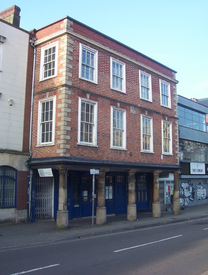
BRISTOL
ST5973SE OLD MARKET STREET, Old Market
901-1/12/1650 (South side)
08/01/59 No.59
Kingsley Hall
GV II*
House, now offices. Dated 1706, restored late C19. Brick-clad
timber-frame with limestone dressings, brick end stack and
paired hipped pantile roofs. Double-depth plan. Early Georgian
style. 3 storeys; 4-window range.
The ground floor is set back beneath the overhanging upper
storeys, supported on five 3/4 columns with flared capitals
and cast pedestals, and projecting one window's depth above
the pavement: above a moulded timber beam, Flemish-bond brick
with yellow headers and red stretchers, rusticated quoins to a
cornice, first-floor drip, and C20 parapet. C19 shop front has
half-glazed doors with margin- and overlights, and windows
with glazing bars; upper windows have brick arches with keys
above bolection-moulded architraves to 6/6-pane horned sashes.
In the middle below the drip is a panel inscribed 1706.
INTERIOR: largely remodelled mid C20; dogleg stair with
quarter landings and turned balusters. The only Bristol
example of a style of urban architecture more common in SW
towns such as the Butterwalks in Dartmouth and Totnes.
Listing NGR: ST5970873137
External links are from the relevant listing authority and, where applicable, Wikidata. Wikidata IDs may be related buildings as well as this specific building. If you want to add or update a link, you will need to do so by editing the Wikidata entry.


Other nearby listed buildings
