Approximate Location Map
Large Map »
Latitude: 51.5262 / 51°31'34"N
Longitude: -2.3067 / 2°18'24"W
OS Eastings: 378818
OS Northings: 180859
OS Grid: ST788808
Mapcode National: GBR 0NT.CM0
Mapcode Global: VH95V.YWXV
Plus Code: 9C3VGMGV+F8
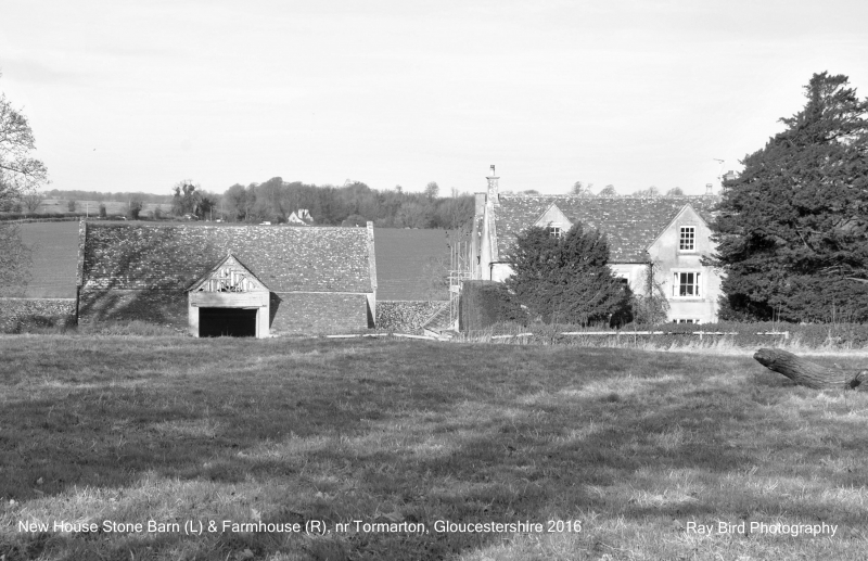
Entry Name: Newhouse Farmhouse and Attached Stable
Listing Date: 17 September 1952
Grade: II
Source: Historic England
Source ID: 1213132
English Heritage Legacy ID: 397658
ID on this website: 101213132
Location: South Gloucestershire, GL9
County: South Gloucestershire
Civil Parish: Tormarton
Traditional County: Gloucestershire
Lieutenancy Area (Ceremonial County): Gloucestershire
Church of England Parish: Tormarton with West Littleton
Church of England Diocese: Bristol
Tagged with: Farmhouse
ST 78 SE TORMARTON C.P. -
3/225 Newhouse Farmhouse and attached
17.9.52 stable
G.V.
II
Farmhouse. C18, early C19 and C20 alterations. Rubble, rendered to front and
left, stone dressings and long and short quoins, stone tiled 2-span roof with
raised coped verges and gable stacks. U-plan. 2½ storeys and 3 windows, all
plate-glass sashes with side-lights, first floor central 4-pane sash, central
gabled porch with ball finial and trellis bargeboard, panelled and glass door with
overlight, 2 gables, each with sash. Left return has C20 window at first floor,
right return has single storey lean-to. Rear has ground floor 3-light casement
to left and 2-light to right, both with relieving arch, three 2-light casements at
first floor, central 4-centred arched opening to triangular recess with segmental-
headed 4-pane window to left and door to right; attached to right a 2-bay single
storey outhouse with 2 doors. Attached to left, 2-bay 1½ storey wing with two
2-light casements, lower attached wing and open passage, 4-pane casement and door
with segmental head; attached at lower ground level a stable block with 2 doors,
3 windows and 2 open-fronted bays with ashlar pier. Interior: not accessible.
Listing NGR: ST7881880859
External links are from the relevant listing authority and, where applicable, Wikidata. Wikidata IDs may be related buildings as well as this specific building. If you want to add or update a link, you will need to do so by editing the Wikidata entry.


Other nearby listed buildings
