Approximate Location Map
Large Map »
Latitude: 51.2942 / 51°17'38"N
Longitude: 0.4133 / 0°24'47"E
OS Eastings: 568355
OS Northings: 157768
OS Grid: TQ683577
Mapcode National: GBR NPC.WTY
Mapcode Global: VHJM5.3QVS
Plus Code: 9F327CV7+M8
Entry Name: Stabling to North East of Went House
Listing Date: 30 November 1993
Grade: II
Source: Historic England
Source ID: 1219408
English Heritage Legacy ID: 392474
ID on this website: 101219408
Location: West Malling, Tonbridge and Malling, Kent, ME19
County: Kent
District: Tonbridge and Malling
Civil Parish: West Malling
Built-Up Area: West Malling
Traditional County: Kent
Lieutenancy Area (Ceremonial County): Kent
Church of England Parish: West Malling St Mary
Church of England Diocese: Rochester
Tagged with: Stable
WEST MALLING
TQ6857 SWAN STREET
1156-0/3/153 (North side)
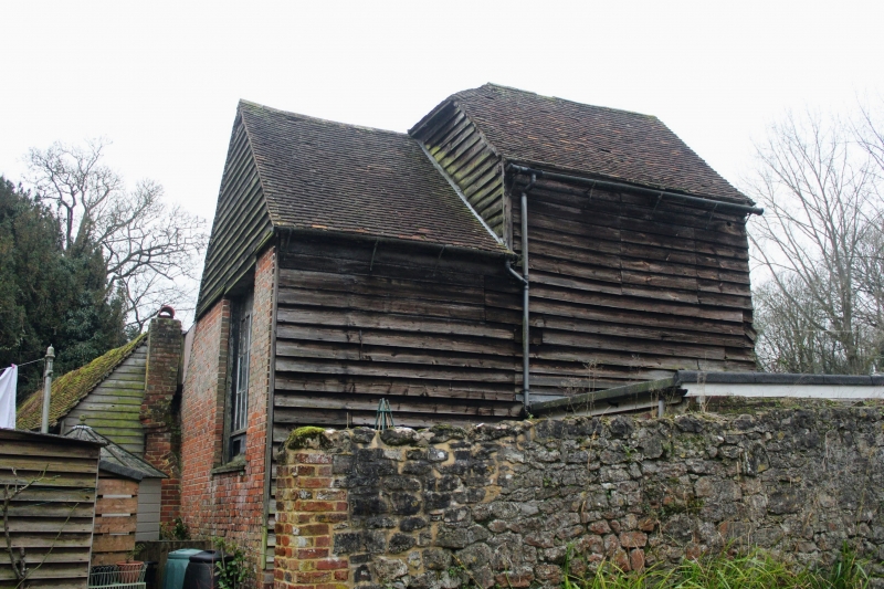
Stabling to north-east of Went House
GV II
Stabling. C18 Weatherboarded with renewed tiled roof. Rear
part has diagonal weatherboarding with 3-light mullioned
window. Low brick extension to east with 2 stable doors.
Listing NGR: TQ6835157767
External links are from the relevant listing authority and, where applicable, Wikidata. Wikidata IDs may be related buildings as well as this specific building. If you want to add or update a link, you will need to do so by editing the Wikidata entry.


Other nearby listed buildings
