Approximate Location Map
Large Map »
Latitude: 50.7266 / 50°43'35"N
Longitude: -2.9347 / 2°56'4"W
OS Eastings: 334125
OS Northings: 92298
OS Grid: SY341922
Mapcode National: GBR PJ.CR9M
Mapcode Global: FRA 47R5.0KC
Plus Code: 9C2VP3G8+J4
Entry Name: Gosling's Bridge
Listing Date: 23 April 1952
Grade: II
Source: Historic England
Source ID: 1229445
English Heritage Legacy ID: 404261
ID on this website: 101229445
Location: Lyme Regis, Dorset, DT7
County: Dorset
Civil Parish: Lyme Regis
Built-Up Area: Lyme Regis
Traditional County: Dorset
Lieutenancy Area (Ceremonial County): Dorset
Church of England Parish: Lyme Regis St Michael the Archangel
Church of England Diocese: Salisbury
Tagged with: Bridge
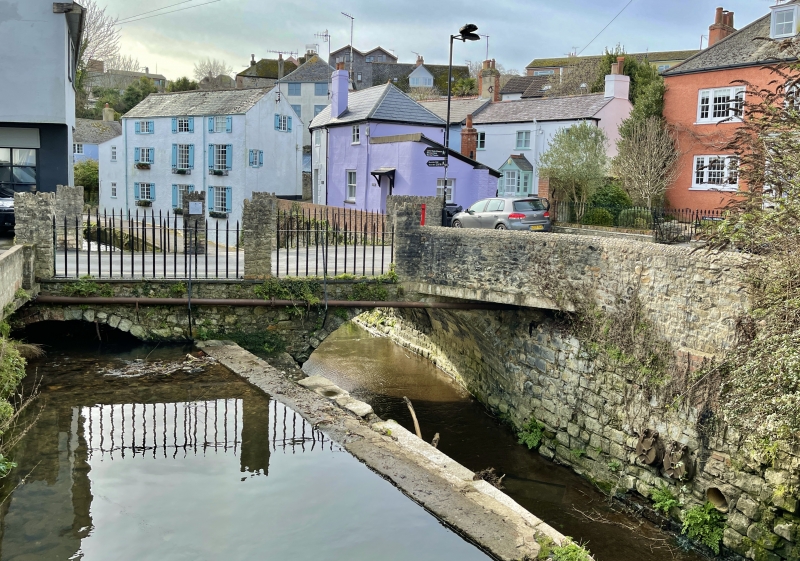
COOMBE STREET
1.
1357
Gosling's Bridge
ST 3492 1/25 23.4.52.
II
2.
Of uncertain date; said to be C17. Faced with blue lias ashlar and with red brick.
Surmounted by painted brick piers with stuccoed capping and by iron railings;
probably C19. 2 arches. Left hand span with roughly 2-centred arch; span to
right of footpath with gently curved arch.
Listing NGR: SY3412592298
External links are from the relevant listing authority and, where applicable, Wikidata. Wikidata IDs may be related buildings as well as this specific building. If you want to add or update a link, you will need to do so by editing the Wikidata entry.


Other nearby listed buildings
