Approximate Location Map
Large Map »
Latitude: 51.1379 / 51°8'16"N
Longitude: 0.9995 / 0°59'58"E
OS Eastings: 609934
OS Northings: 141902
OS Grid: TR099419
Mapcode National: GBR SYD.MJH
Mapcode Global: VHKKQ.8NSK
Plus Code: 9F324XQX+5R
Entry Name: Malthouse and Oast with Wall and Gate About 15 Metres West and South West of Ivy Cottage
Listing Date: 16 February 1989
Grade: II
Source: Historic England
Source ID: 1232712
English Heritage Legacy ID: 408017
ID on this website: 101232712
Location: Brabourne, Ashford, Kent, TN25
County: Kent
District: Ashford
Civil Parish: Brabourne
Traditional County: Kent
Lieutenancy Area (Ceremonial County): Kent
Tagged with: Malt house
TR 04 SE BRABOURNE CANTERBURY ROAD
East Brabourne
(east side)
4/9 Malthouse and
oast with wall
and gate about
15 metres west
and south west
of Ivy Cottage
GV II
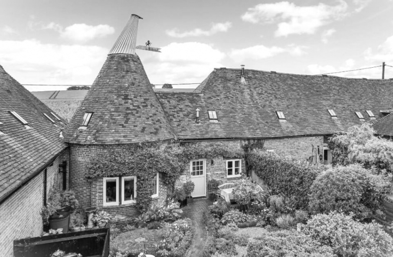
Malthouse, oast and wall. C17 malthouse and early C19 oast complex
and wall. Red brick on ragstone with plain tiled roof. Malthouse with
ragstone plinth, sometimes half the height of the single storey.
Brickwork in irregular English and Garden wall bonds. Roof hipped,
stepped up to left. Three massive buttresses to roadside, with 8
boarded window openings, and central group of 4 brick ventilation
slits. Boarded doors to left, centre left and end right. Attached
to left the red brick garden wall to Ivy Cottage, about 3 feet high,
ramped at each end of approximately 20 metre lengths with central
simple iron gate, the piers with cast iron capitals and finials, and
dogtooth band half-way up the piers. To south of Maltings the early
C19 oast complex, with 2 storey stowage with double height cart doors,
hipped roof and roundel to rear. Hipped stowage barn to right, with
2 hipped half dormers, wooden casement, cart doors and boarded door
to left. Rear courtyard with boundary walls and outbuilding. A
second kiln and roundel was formerly behind (ie to east of) the
Maltings building, 2 single storey vestigial buildings survive,
of red brick and ragstone.
Listing NGR: TR0993441902
External links are from the relevant listing authority and, where applicable, Wikidata. Wikidata IDs may be related buildings as well as this specific building. If you want to add or update a link, you will need to do so by editing the Wikidata entry.


Other nearby listed buildings
