Approximate Location Map
Large Map »
Latitude: 53.2089 / 53°12'32"N
Longitude: -0.817 / 0°49'1"W
OS Eastings: 479105
OS Northings: 368636
OS Grid: SK791686
Mapcode National: GBR CJW.XYZ
Mapcode Global: WHFGX.FL5V
Plus Code: 9C5X655M+H6
Entry Name: The Grange and Attached Wall and Outbuildings
Listing Date: 1 February 1967
Grade: II
Source: Historic England
Source ID: 1233799
English Heritage Legacy ID: 409376
ID on this website: 101233799
Location: Normanton on Trent, Bassetlaw, Nottinghamshire, NG23
County: Nottinghamshire
District: Bassetlaw
Civil Parish: Normanton on Trent
Built-Up Area: Normanton on Trent
Traditional County: Nottinghamshire
Lieutenancy Area (Ceremonial County): Nottinghamshire
Church of England Parish: Normanton-upon-Trent
Church of England Diocese: Southwell and Nottingham
Tagged with: Architectural structure
SK 76 NE
5/52
1.2.67
NORMANTON-ON-TRENT
MAIN STREET
(west side)
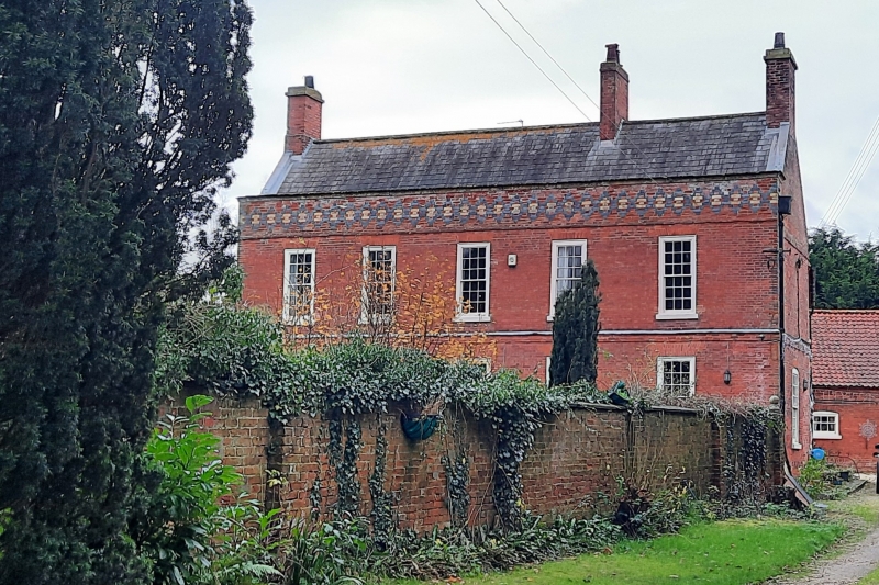
The Grange and attached wall and outbuildings
G.V.
II
House, wall and outbuildings including a barn and pigeoncote.
House mid C18, refaced mid C19, dated 1747 on rainwater head.
Red brick with some blue and yellow brick and ashlar. Slate roof
with 2 gable and single ridge red brick stacks. Raised gables
with tumbled in brickwork. Ashlar coped C19 parapet decorated
with blue brick diaper with some yellow brick infill. Set on a
plinth with a moulded brick band over. 2 storeys, 5 bays with a
first floor band and a first floor dripmould. Central 6 fielded
panel door with glazing bar overlight. Either side are 2 glazing
bar sashes with 5 similar sashes above. The north/right side has
a rainwater head inscribed 'TFA 1747'. Extending from the left
for 14 metres is an ashlar coped red brick wall. To the rear are
various 2 storey extensions. Attached to the rear right is a C18
range of buildings, having from left to right an outbuilding, a
barn, and a pigeoncote. Red brick, pantile roofs, dogtooth eaves
with dogtooth and dentil to the pigeoncote. Single red brick
stack to the right gable of the outbuilding. Raised and brick
coped gables with kneelers to the barn and pigeoncote. Single
storey outbuilding with a single small glazing bar sash under a
segmental arch with a larger similar sash to the right. The 2
storey barn has a doorway with a part glazed door under segmental
arch with a blocked doorway to the right and further right a
large blocked doorway. The 2 storey plus attic pigeoncote has a
doorway with wooden door and round arched over-panel. Under the
eaves are entrances for pigeons and perches. Extending from the
front is a C20 brick and pantile single storey single bay
outbuilding and 2 bay garage. Interior of pigeoncote has brick
nesting boxes.
Listing NGR: SK7910568636
External links are from the relevant listing authority and, where applicable, Wikidata. Wikidata IDs may be related buildings as well as this specific building. If you want to add or update a link, you will need to do so by editing the Wikidata entry.


Other nearby listed buildings
