Latitude: 52.8961 / 52°53'46"N
Longitude: -2.6658 / 2°39'56"W
OS Eastings: 355306
OS Northings: 333395
OS Grid: SJ553333
Mapcode National: GBR 7M.PLYN
Mapcode Global: WH9C1.0GVL
Plus Code: 9C4VV8WM+FM
Entry Name: Providence Grove
Listing Date: 16 September 1987
Grade: II
Source: Historic England
Source ID: 1236415
English Heritage Legacy ID: 427301
ID on this website: 101236415
Location: Prees, Shropshire, SY13
County: Shropshire
Civil Parish: Prees
Built-Up Area: Prees
Traditional County: Shropshire
Lieutenancy Area (Ceremonial County): Shropshire
Church of England Parish: Prees St Chad
Church of England Diocese: Lichfield
Tagged with: House
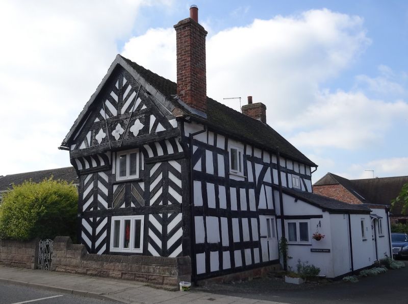
PREES C.P. SHREWSBURY STREET (west side) SJ 5433-5533 14/108 No. 28 (Providence Grove) - GV II
House. C15, partly remodelled late C16 or early C17 with later additions and alterations. Timber framed with rendered wattle and daub infill on high cement-rendered plinth; plain tile roof. Original plan an open hall of 2 or possibly more framed bays with present right bay added or rebuilt when rest of house was floored over in late C16 or early C17; eaves slightly raised, probably in late C17 or early C18. 2 storeys with jettied right gable end. Framing: irregular square and rectangular panels with long curving tension braces to C15 part; rectangular panels, 2 from high cill to wall-plate, and short straight tension braces to C17 part; gable of C17 part has herringbone decoration to first floor with coved jetty supported on carved corner brackets to attic; moulded bressumer with billet moulding and 3 crudely carved quatrefoils above (middle with date "1611" painted on infill); king- strut and herringbone decoration to apex. Mid-C20 casements throughout, 2 on first floor to left and one on either side of roughly central entrance; half-glazed door under C19 gabled hood. Internal red brick end stack to left and integral lateral stack to rear on right. Interior: left ground-floor room has massive chamfered cross beam supported on carved wall posts and flat heavy joists. Large stack with partly infilled inglenook fireplace and oak winder staircase to right. C15 roof survives in 2 bays to left with central cambered tie beam exposed to first floor; remainder partly visible in roof space; king-strut from collar has mortice indicating former presence of collar purlin, showing that roof was originally of crown-post construction; curved windbraces and mortices for large curving struts from wall posts to tie beam, as visible to left gable end externally. C20 flat-roofed additions set back to left and rear are not of special architectural interest. There is a local tradition that the house was once much larger and the date "1611" to the right gable end is based on local hearsay. There are several other houses in the vicinity with similar late C16/early C17 decorative gables.
Listing NGR: SJ5530633395
External links are from the relevant listing authority and, where applicable, Wikidata. Wikidata IDs may be related buildings as well as this specific building. If you want to add or update a link, you will need to do so by editing the Wikidata entry.


Other nearby listed buildings