Approximate Location Map
Large Map »
Latitude: 51.5136 / 51°30'49"N
Longitude: -0.1633 / 0°9'47"W
OS Eastings: 527548
OS Northings: 181009
OS Grid: TQ275810
Mapcode National: GBR 7C.JL
Mapcode Global: VHGQZ.4710
Plus Code: 9C3XGR7P+CM
Entry Name: 6, Stanhope Place W2
Listing Date: 10 April 1975
Grade: II
Source: Historic England
Source ID: 1236639
English Heritage Legacy ID: 427678
ID on this website: 101236639
Location: Paddington, Westminster, London, W2
County: London
District: City of Westminster
Electoral Ward/Division: Hyde Park
Parish: Non Civil Parish
Built-Up Area: City of Westminster
Traditional County: Middlesex
Lieutenancy Area (Ceremonial County): Greater London
Church of England Parish: St John Evan Hyde Park Crescent
Church of England Diocese: London
Tagged with: Building
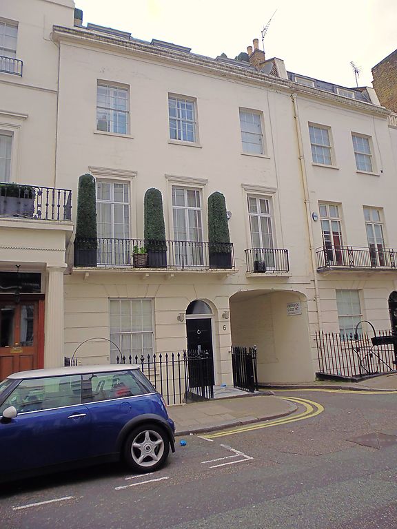
TQ 2781 SE CITY OF WESTMINSTER STANHOPE PLACE, W2
54/87
10.4.75 No. 6
G.V. II
Terraced town house incorporating mews entrance. c.1828-30, possibly by
George Gutch; part of first phase of Tyburnia development. Stuccoed with
joint lines incised and channelled ground floor; concealed slate roof. 3
storeys and basement. 3 windows wide. Semicircular arched doorway in
centre adjoining right hand segmental arched mews entrance; panelled door
with reeded jambs and head under fanlight (mid C.20 canopy added). Ground
floor windows altered; 1st floor has margin glazed French casements
recessed in shallow moulded architrave surrounds with cornices; 2nd floor
has recessed glazing bar sashes. 1st floor plat band. Crowning cornice
and blocking course. Original, cast iron, geometric patterned balcony to
1st floor. Cast iron area railings with urn finials. Part of Tyburnia,
the development of the Bishop of London's Estate planned by S.P. Cockerell
in 1827 but laid out to modified plan by his successor George Gutch.
"The History of Tyburnia"; G. Toplis in Country Life, 15,22 Nov. 1973.
Listing NGR: TQ2754881008
External links are from the relevant listing authority and, where applicable, Wikidata. Wikidata IDs may be related buildings as well as this specific building. If you want to add or update a link, you will need to do so by editing the Wikidata entry.


Other nearby listed buildings
