Approximate Location Map
Large Map »
Latitude: 51.3817 / 51°22'53"N
Longitude: 0.2172 / 0°13'1"E
OS Eastings: 554389
OS Northings: 167066
OS Grid: TQ543670
Mapcode National: GBR TS.RDW
Mapcode Global: VHHP6.QJ5P
Plus Code: 9F3296J8+MV
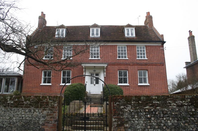
Entry Name: Mount Pleasant
Listing Date: 1 June 1967
Grade: II
Source: Historic England
Source ID: 1238235
English Heritage Legacy ID: 415687
ID on this website: 101238235
Location: Farningham, Sevenoaks, Kent, DA4
County: Kent
District: Sevenoaks
Civil Parish: Farningham
Built-Up Area: Eynsford
Traditional County: Kent
Lieutenancy Area (Ceremonial County): Kent
Church of England Parish: Farningham St Peter and St Paul
Church of England Diocese: Rochester
Tagged with: Architectural structure
FARNINGHAM SPAREPENNY LANE
1.
5280
Mount Pleasant
TQ 5467 9/139 1.6.67
II GV
2.
Circa 1720. Two parallel ranges. Two storeys attic and basement red brick. Tiled
roof with 3 hipped dormers. Wooden eaves cornice. Brick stringcourse. Three
sashes with glazing bars intact on the first floor only. Doorcase up 6 steps
with pilasters and wide flat hood over.
Listing NGR: TQ5438967063
External links are from the relevant listing authority and, where applicable, Wikidata. Wikidata IDs may be related buildings as well as this specific building. If you want to add or update a link, you will need to do so by editing the Wikidata entry.


Other nearby listed buildings
