Approximate Location Map
Large Map »
Latitude: 53.9637 / 53°57'49"N
Longitude: -1.0792 / 1°4'45"W
OS Eastings: 460507
OS Northings: 452345
OS Grid: SE605523
Mapcode National: GBR NQXL.4W
Mapcode Global: WHFC3.DMBR
Plus Code: 9C5WXW7C+F8
Entry Name: 26, Lord Mayors Walk
Listing Date: 24 June 1983
Last Amended: 14 March 1997
Grade: II
Source: Historic England
Source ID: 1257458
English Heritage Legacy ID: 463842
ID on this website: 101257458
Location: York, North Yorkshire, YO31
County: York
Electoral Ward/Division: Guildhall
Parish: Non Civil Parish
Built-Up Area: York
Traditional County: Yorkshire
Lieutenancy Area (Ceremonial County): North Yorkshire
Church of England Parish: York St Thomas with St Maurice
Church of England Diocese: York
Tagged with: Building
YORK
SE6052SE LORD MAYOR'S WALK
1112-1/14/560 (North East side)
24/06/83 No.26
(Formerly Listed as:
LORD MAYOR'S WALK
Nos.26-34 (Even))
GV II
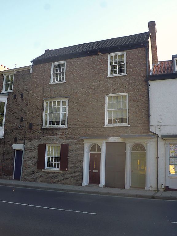
Shop and flats. Early C19. Brick with concrete tile roof.
EXTERIOR: 3 storeys and 2 bays. The windows to the upper
storeys are glazing bar sashes with segmental brick heads,
except for the left-hand window on the 1st floor which is
tripartite and bowed with glazing bar sashes and a reeded
surround. At the left on the ground floor there is a shopfront
with a recessed central doorway and timber pilasters and
fascia. To its right there is a doorcase with engaged reeded
columns, a panelled frieze, plain cornice and a door with 6
raised and fielded panels. The semicircular overlight has a
single vertical glazing bar. To the right there is an entrance
to a passageway, with a lintel and a door with 6 sunken
panels. A second doorcase at the far right forms part of No.24
(qv). Chimney on right-hand gable.
INTERIOR: not inspected.
(An Inventory of the Historical Monuments of the City of York:
RCHME: Outside the City Walls East of the Ouse: HMSO: 1975-:
83).
Listing NGR: SE6050752345
External links are from the relevant listing authority and, where applicable, Wikidata. Wikidata IDs may be related buildings as well as this specific building. If you want to add or update a link, you will need to do so by editing the Wikidata entry.


Other nearby listed buildings
