Approximate Location Map
Large Map »
Latitude: 51.2522 / 51°15'7"N
Longitude: 0.4842 / 0°29'3"E
OS Eastings: 573460
OS Northings: 153269
OS Grid: TQ734532
Mapcode National: GBR PRC.H7X
Mapcode Global: VHJMD.BSVF
Plus Code: 9F327F2M+VM
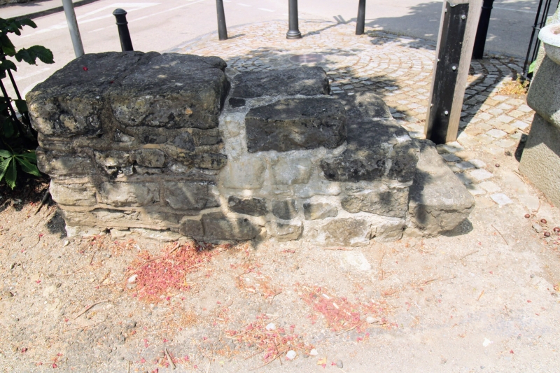
Entry Name: Mounting Block to Centre of Junction with Station Road
Listing Date: 26 February 1987
Grade: II
Source: Historic England
Source ID: 1263699
English Heritage Legacy ID: 431658
ID on this website: 101263699
Location: East Farleigh, Maidstone, Kent, ME15
County: Kent
District: Maidstone
Civil Parish: East Farleigh
Traditional County: Kent
Lieutenancy Area (Ceremonial County): Kent
Church of England Parish: East Farleigh
Church of England Diocese: Rochester
Tagged with: Mounting block
LOWER ROAD
TQ 75 SW EAST FARLEIGH
(North Side)
2/33 Mounting Block to
centre of junction
with Station Road
GV II
Mounting block. Early C20 or earlier. Ragstone, roughly coursed. Free-
standing, with 4 stone steps, set to west of drinking trough.
Listing NGR: TQ7346053269
External links are from the relevant listing authority and, where applicable, Wikidata. Wikidata IDs may be related buildings as well as this specific building. If you want to add or update a link, you will need to do so by editing the Wikidata entry.


Other nearby listed buildings
