Approximate Location Map
Large Map »
Latitude: 51.5338 / 51°32'1"N
Longitude: -0.1817 / 0°10'54"W
OS Eastings: 526212
OS Northings: 183223
OS Grid: TQ262832
Mapcode National: GBR 34.DB
Mapcode Global: VHGQR.SQS1
Plus Code: 9C3XGRM9+G8
Entry Name: 57 and 59, Marlborough Place NW8
Listing Date: 18 September 1975
Grade: II
Source: Historic England
Source ID: 1273619
English Heritage Legacy ID: 417625
ID on this website: 101273619
Location: St John's Wood, Westminster, London, NW8
County: London
District: City of Westminster
Electoral Ward/Division: Abbey Road
Parish: Non Civil Parish
Built-Up Area: City of Westminster
Traditional County: Middlesex
Lieutenancy Area (Ceremonial County): Greater London
Church of England Parish: St Mark Hamilton Terrace
Church of England Diocese: London
Tagged with: Building
TQ 2683 SW CITY OF WESTMINSTER MARLBOROUGH PLACE, NW8
11/47 (south side)
18.9.75 Nos 57 and 59
GV II
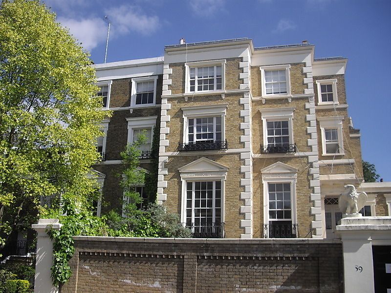
A pair of semi-detached houses, c1840 with late C20 alterations.
MATERIALS: The pair are constructed of yellow London Stock brick with stuccoed
dressings and timber sliding sash windows. The roof is set back behind a stuccoed
parapet.
PLAN: The interior of No. 59 has a raised ground floor of informal plan, with the
entrance hall leading to the stair hall running at 90 degree along the axis of the building. There is a large room to the front and two to the rear all of which seem to reflect the mid C19 layout. A timber cantilevered stair with cast iron balusters rises to the second floor. The first floor is more altered though the upper floor retains more legible layout.
EXTERIOR: The façade is of three storeys with a raised basement and is five bays
wide. The marginal bays are set back from the main front and contain entrances under projecting Doric porches, both with triglyph friezes, cornice with mutules and pilasters.The main body of the building is treated as one house, with the central projecting bay and the western bay comprising one dwelling, the two eastern bays comprising the other. The whole is finished with stuccoed quoins to margins and the central bay, string courses to first and second floor with a deep plain stucco cornice above. All the windows have stucco surrounds, those on the ground floor with pointed pediments, those above with a plainer flat frieze and cornice. The central bays sash windows are of tripartite pattern, the others have single sashes with recessed frames. There are cast iron balconies to ground and first floors. The raised entrances are approached by flights of stone steps, those to No. 59 having been rebuilt in the late C20. Both houses have been extended to east and west in the C20, the rear is also much altered. The glazed canopy covering the approach from the street to entrance described at the time of original listing in 1975 has been removed.
INTERIOR: In No. 59, the ground floor principal rooms and hall all have decorative plasterwork, elaborate door cases and doors and chimney pieces all of late C2O date, with the exception of the piece in the rear room which is of late C18 date, and an importation. The roof structure, though not inspected, is understood to have been entirely replaced and reconfigured in the late C20.
The interior of No. 57 was not inspected.
HISTORY: Marlborough Place lies close to the centre of St. John's Wood, the first and therefore most celebrated of London's C19 suburbs. The Eyre Estate to the north of Marylebone Road, acquired by Henry Simon Eyre, a City merchant in 1732, was amongst the last of the substantial family estates to be settled. The earliest plans for its development date from 1794, though this layout, with inner and outer circus drives was never carried out. A modified version appears again in 1803, though the re-opening of the Napoleonic conflict in this year appears to have prevented its initiation. What was common to both plans however, and indeed to the pattern of development on the estate when building commenced in the 1820s, was the provision of housing as semi-detached villas set in generous grounds. This pattern of development was sustained on the Estate, and indeed that of the adjacent Portland Estate, through to the mid C19, though it was supplemented with traditional terraces. This most influential sylvan residential enclave was to set the pattern for the suburban development of London and indeed many other cities and towns in England for the next century. Its development therefore has to be seen as a very significant phase in evolution of urban planning in England.
Marlborough Place was first rated in 1829 and the map of St Marylebone and Paddington by Bartlett and Britton of 1834 shows development in the first section of Marlborough Road, west of Abbey Road and fields at the the site where Nos. 57-59 were subsequently built in c1840. The property appears with three other pairs of houses at this location on the St Marylebone Parish map of 1846. The house was split into four flats in the early 1950s, one of which for a time was occupied by the composer Benjamin Britten, before it again reverted to a single dwelling in the early 1990s.
SUMMARY OF IMPORTANCE: Nos. 57-59 Marlborough Place, a good example of the early mid-C19 semi-detached villas erected on the Eyre Estate, are of special architectural interest on account of their early semi-detached format and their architectural form and detailing expressed on their front elevations. This architectural interest is defined by the treatment of the two dwellings as a single entity and in their embellishment, articulated in the stuccoed enrichment of window architraves, cornice, decorative quoin-work and the Doric porches. The pair are also of interest as components of a strong group of villas that make up Marlborough Place which together, express the mature characteristics of the Eyre Estate, the first suburban development of the early and mid C19. Alterations and remodelling in the late-C20, particularly to No.59, are not of special interest.
SOURCES: Summerson, John. 4th Edition, Georgian London 1948; 157-159.
Weinreb, Ben and Hibbert, Christopher (eds) The London Encyclopaedia 1983; 514, 746-748.
Listing NGR: TQ2621883227
External links are from the relevant listing authority and, where applicable, Wikidata. Wikidata IDs may be related buildings as well as this specific building. If you want to add or update a link, you will need to do so by editing the Wikidata entry.


Other nearby listed buildings
