Approximate Location Map
Large Map »
Latitude: 52.9228 / 52°55'22"N
Longitude: -1.4793 / 1°28'45"W
OS Eastings: 435103
OS Northings: 336280
OS Grid: SK351362
Mapcode National: GBR PJF.TM
Mapcode Global: WHDGT.7STP
Plus Code: 9C4WWGFC+47
Entry Name: Nos 2 to 40 (even) The Strand including entrance to Strand Arcade
Listing Date: 24 February 1977
Grade: II
Source: Historic England
Source ID: 1279060
English Heritage Legacy ID: 404305
ID on this website: 101279060
Location: Derby, Derbyshire, DE1
County: City of Derby
Electoral Ward/Division: Arboretum
Parish: Non Civil Parish
Built-Up Area: Derby
Traditional County: Derbyshire
Lieutenancy Area (Ceremonial County): Derbyshire
Church of England Parish: Derby St Alkmund and St Werburgh
Church of England Diocese: Derby
Tagged with: Building
SK 3536 SW 1/284
5170
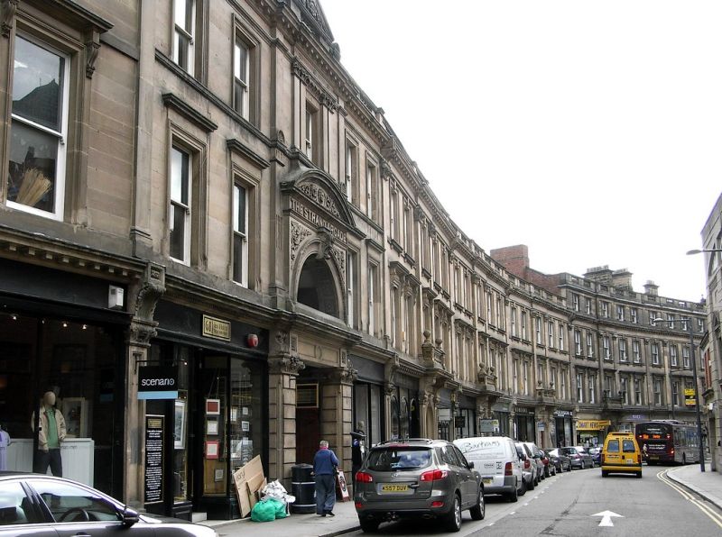
STRAND (North Side),
Nos 2 to 40 (even) including Entrance to Strand Arcade
GV II
A continuous range. 1881. Neo-classical style; ashlar; 3 and 4 storeys; range of sash windows (no glazing bars) in moulded architraves with cornices on consoles; continuous modillion cornice at 1st floor, and at 3rd floor to form eaves cornice of 3-storeyed portion of range; pilasters rising over lst and 2nd storeys at alternate bays; 3 doorways and entrance to Strand Arcade (between Nos 28 and 30) with pilasters at sides, semi-circular arched heads with foliated keyblocks, elaborately carved spandrels and open balustrades; continuous cornice at 1st floor. No 2 has doorway on splay to return side in rusticated surround and arcaded windows to front; doorways generally with 12-panelled divided doors; moulded eaves cornice surmounted by open balustrading. Inserted modern shop fronts. Entrance to Strand Arcade only included as part of facade.
Nos 2 to 40 (even) including Entrance to Strand Arcade form a group with No 17 to 21 (odd) and No 25 St James's Street.
Listing NGR: SK3510336280
External links are from the relevant listing authority and, where applicable, Wikidata. Wikidata IDs may be related buildings as well as this specific building. If you want to add or update a link, you will need to do so by editing the Wikidata entry.


Other nearby listed buildings
