Approximate Location Map
Large Map »
Latitude: 51.4632 / 51°27'47"N
Longitude: -2.6182 / 2°37'5"W
OS Eastings: 357148
OS Northings: 173979
OS Grid: ST571739
Mapcode National: GBR C2G.WB
Mapcode Global: VH88M.KHQ6
Plus Code: 9C3VF97J+7P
Entry Name: Emanuel Court
Listing Date: 6 February 1976
Last Amended: 30 December 1994
Grade: II
Source: Historic England
Source ID: 1282284
English Heritage Legacy ID: 379682
ID on this website: 101282284
Location: Clifton, Bristol, BS8
County: City of Bristol
Electoral Ward/Division: Clifton
Parish: Non Civil Parish
Built-Up Area: Bristol
Traditional County: Gloucestershire
Lieutenancy Area (Ceremonial County): Bristol
Church of England Parish: Clifton Christ Church with Emmanuel
Church of England Diocese: Bristol
Tagged with: Building
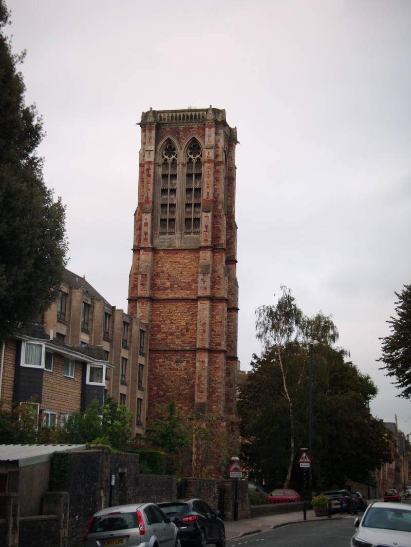
BRISTOL
ST5773NW GUTHRIE ROAD, Clifton
901-1/2/871 (South side)
06/02/76 Emanuel Court
(Formerly Listed as:
GUTHRIE ROAD
Emmanuel Church)
II
Church tower, now flats. 1869. By J Norton. The body of the
church was demolished in c1970. Snecked red Pennant rubble
with limestone ashlar dressings. Square in plan. Early English
Gothic Revival style. A 5-stage tower, angle buttresses with
gableted tops and a rounded ashlar stair tower to the 4th
stage between the buttresses to the NW. N door of 3 orders
with foliate capitals, tympanum carved with diapers and a
statue of Christ, above a trumeau with shouldered arched
doors; windows to the W and E are paired lancets in a pointed
arch on banded shafts, with a gable hood and finial. 3 stepped
lancets with plate tracery and hoodmould to the 2nd stage, 2
thin lancets to the 3rd and a single one to the 4th, all to
the N elevation only; the belfry has 2 tall louvred lancets of
2 orders with trefoil heads, with gargoyles to the corners of
an openwork parapet. INTERIOR: converted to flats. Body of
church demolished to build sheltered accommodation, of which
tower is part.
(The Buildings of England: Pevsner N: North Somerset and
Bristol: London: 1958-: 389).
Listing NGR: ST5714873979
External links are from the relevant listing authority and, where applicable, Wikidata. Wikidata IDs may be related buildings as well as this specific building. If you want to add or update a link, you will need to do so by editing the Wikidata entry.


Other nearby listed buildings
