Approximate Location Map
Large Map »
Latitude: 54.5459 / 54°32'45"N
Longitude: -1.9218 / 1°55'18"W
OS Eastings: 405157
OS Northings: 516738
OS Grid: NZ051167
Mapcode National: GBR HH0W.Q6
Mapcode Global: WHB4D.GZ3Y
Plus Code: 9C6WG3WH+97
Entry Name: 55, Galgate
Listing Date: 22 February 1973
Last Amended: 28 November 1994
Grade: II
Source: Historic England
Source ID: 1282842
English Heritage Legacy ID: 388679
ID on this website: 101282842
Location: Barnard Castle, County Durham, DL12
County: County Durham
Civil Parish: Barnard Castle
Built-Up Area: Barnard Castle
Traditional County: Durham
Lieutenancy Area (Ceremonial County): County Durham
Church of England Parish: Barnard Castle with Whorlton
Church of England Diocese: Durham
Tagged with: Building
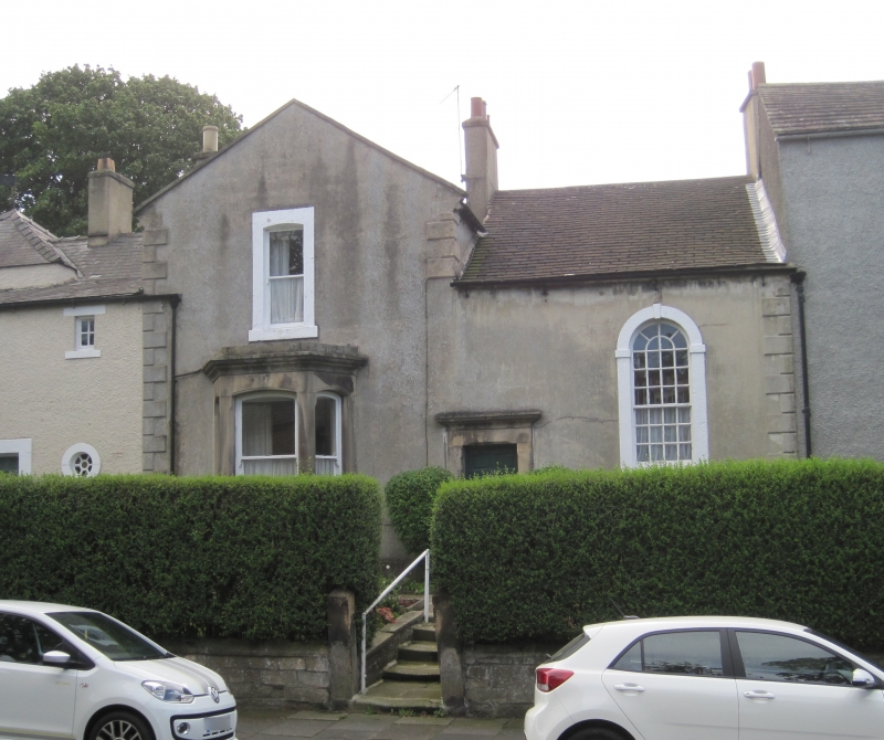
BARNARD CASTLE
NZ0516NW GALGATE
770-1/4/51 (South East side)
22/02/73 No.55
(Formerly Listed as:
GALGATE
(South side)
Nos.53,55,57,59,59A (Odd))
GV II
House, formerly part of larger complex. 1760 with C19
alterations. Rough render with ashlar quoins and dressings,
some painted; roof of synthetic plain tiles with stone gable
copings and rendered chimneys. 2 storeys; 2-window range.
Gabled left bay and lower right bay. 6-panel door at left of
right bay in C19 stop-chamfered corniced stone surround. At
left, C19 ashlar canted bay window has shallow segmental heads
with cornice and blocking course. Similar head to single
narrow sash above in plain stone surround with projecting
stone sill. At right, keyed round-arched surround with imposts
to tall stair sash with round-arched glazing bars. Central and
left ridge chimneys.
INTERIOR: ramped staircase handrail visible in stair window.
HISTORY: this was part of the home of William Hutchinson, the
historian of County Durham, in the late C18.
(Heritage Series, Discovery Guides: Tallantire W L: Barnard
Castle: Middleton-in-Teesdale: 1988-: 10).
Listing NGR: NZ0515716738
External links are from the relevant listing authority and, where applicable, Wikidata. Wikidata IDs may be related buildings as well as this specific building. If you want to add or update a link, you will need to do so by editing the Wikidata entry.


Other nearby listed buildings
