Approximate Location Map
Large Map »
Latitude: 52.7571 / 52°45'25"N
Longitude: 0.3965 / 0°23'47"E
OS Eastings: 561822
OS Northings: 320411
OS Grid: TF618204
Mapcode National: GBR N3Q.51W
Mapcode Global: WHJP1.2Y3R
Plus Code: 9F42Q94W+RJ
Entry Name: 78 Chapel Street
Listing Date: 7 June 1972
Last Amended: 31 August 2018
Grade: II
Source: Historic England
Source ID: 1291370
English Heritage Legacy ID: 384088
ID on this website: 101291370
Location: North End, King's Lynn and West Norfolk, Norfolk, PE30
County: Norfolk
District: King's Lynn and West Norfolk
Electoral Ward/Division: St Margarets with St Nicholas
Parish: Non Civil Parish
Built-Up Area: King's Lynn
Traditional County: Norfolk
Lieutenancy Area (Ceremonial County): Norfolk
Tagged with: Building
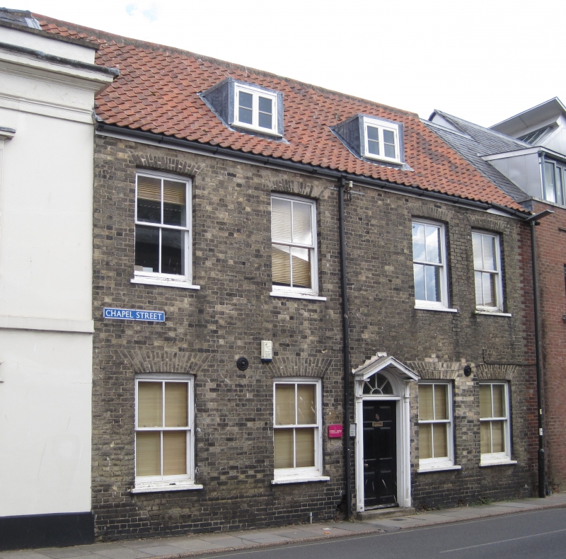
Terraced brown brick house, built in the late C18, and extended to the rear in the C19 and early C21, now offices.
Terraced brown brick house, built in the late C18, and extended to the rear in the C19 and early C21, now offices.
MATERIALS: Brown brick walls with a pantile roof.
PLAN: Rectangular-plan house facing west to Chapel Street, with a C19 single-storey lean-to extension and early-C21 two-storey lean-to extension to the rear elevation.
EXTERIOR: Four-bay two-and-half storey terraced house, constructed of brown brick in the late C18. The pitched pantiled roof has a cat-slide roof to the rear, which descends low over the ground floor. The roof has two flat-roofed dormers to the front (west) slope, and a single flat-roofed dormer to the rear (east) slope. It is likely the roof covering was replaced in the late C20. The front elevation has four four-over-four pane timber sash windows to the ground and first floors under gauged skewback arches, and timber casements to the attic (all replaced around 2000). The door, between the central windows, is timber-panelled with a four-vane fanlight and open pediment hood over. A cast-iron boot scrape survives to the north side of the door. There are two lean-to extensions to the rear (east) elevation: a C19 single-storey extension leans against number 80 to the north, and an early-C21 two-storey extension leans against number 72 to the south, replacing an earlier structure.
INTERIOR: The building generally has a two-cell plan, the ground floor formerly having a room north and south of a central entrance hall, until the wall between the entrance hall and south room was removed around 2000. At the east and west ends of the former entrance hall, timber-panelled doors survive, each with a spoked fanlight over (round-arched to the west and segmental to the east). The cornices were replaced and imitation fire surrounds introduced in both ground floor rooms around 2000. The stair is located at the rear of the building, rising south to the first floor, with plain timber stick balusters and a simple wooden handrail continuing along the first floor landing (appearing to be of C19 construction). The west wall of the kitchen (constructed around 2010) is constructed of coursed rubble stone under the stair, with the outline of a former square-headed door opening, suggesting this may originally have been the rear elevation of the house, and the current stair is a later configuration.
The first floor formerly had two large rooms, however divisions were removed around 2000 to provide a single office space. The first floor rooms retain late-C19 or early-C20 timber panelling above a dado rail, and timber-panelled doors on the east wall. The balustrade of the first floor landing suggests the configuration may have been altered around 2000 to provide office space at the north end. The attic, accessed from a door on the west wall of the first floor corridor, has a corridor along the east side, and two rooms north and west of the corridor. Some of the timber-framed roof structure is exposed, and partitions are composed of lath and plaster.
SUBSIDIARY FEATURES: To the rear of the building, there are red brick boundary walls to the east and north-east boundary of the site, with a square-headed door opening to the churchyard of the Chapel of St Nicholas. The rear yard has limestone paving slabs, and late-C20 single-storey storage cabins to the east of the building.
King’s Lynn, first called Bishop’s Lynn, was founded in 1095 by Bishop Herbert de Losinga, who in the previous year had transferred the see from Thetford to Norwich. There was already an existing settlement which appears to have been based around a salt-water lagoon, or series of inlets, with its centre round the present All Saints Church. Losinga’s town developed to the north of this, between All Saints Church and Saturday Market Place where St Margaret’s Church and Priory were established from Norwich around 1100. Rapid expansion from the C12 onwards required an extension of the town, and Bishop William Turbe laid out a new settlement north of the Purfleet from around 1145, with its market at Tuesday Market Place and the Chapel of St Nicholas as a chapel of ease to St Margaret’s. Both settlements were united under a royal charter in 1204, the united town being named Bishop’s Lynn. Until the early C13, the Great Ouse emptied via the Wellstream at Wisbech, however following floods in the C13, the river was redirected to join the Wash at Bishop’s Lynn. The town became one of England’s busiest ports, serving the Ouse and its tributaries, exporting wool and cloth, and importing wine, timber and luxury goods, being adopted as a member of the original medieval Hanseatic League. This extremely influential trading association linked a group of towns around the Baltic and the North Seas, and played an important role in the prosperity and development of Bishop’s Lynn as a national port, which by the C14, was ranked as the third port of England (after London and Southampton).
Losinga’s town round the Saturday Market was protected from the river immediately to its west by the ‘great bank’, an earthwork which ran along the present line of Nelson Street, St Margaret’s Place and Queen Street. By about 1500 the river had moved approximately 50m west and was consolidated another 45m by the new South Quay in 1855. The period of development of the area between the Millfleet and Purfleet can therefore be identified, as well as building types and plans. The generous-sized plots are reflected in the surviving buildings dating from the C14 to the C17, which surround open courtyards. To the north, on Bishop Turbe’s ‘newe lande’, much the same pattern emerges: originally the west side of Tuesday Market Place was washed by the river, with King Street forming the line of the bank. The west side of King Street was built upon in the C13, with narrow plots, elongating in stages until river movement ceased in the C17. As land became available, warehouses were built straight onto the river front. When Henry VIII dissolved the monasteries in 1536-1537, the town and manor became royal property, and Bishop’s Lynn was renamed King’s Lynn or Lynn Regis.
Lynn’s prosperity as a national port was based entirely on trade, and the merchant class dominated the social and economic life of the town until the C19. When the Fens began to be drained in the mid-C17 and land turned to agricultural use, King’s Lynn grew prosperous from the export of corn: cereal export dominated from the C16, and especially in the C18. Coal and wine continued to be imported for distribution inland, and until the railway age, Lynn was the chief East Anglian port for both. Prosperity continued until continental trade was disturbed by the Napoleonic Wars (1803-1815), followed by a brief revival. The economy and population dwindled following the relatively late arrival of railway services to King’s Lynn in 1847, compounded by the irrevocable decline of coastal trading.
78 Chapel Street was built near the junction of Chapel Street, St Nicholas Street and St Ann’s Street in the late C18, replacing an earlier building on the same site. Chapel Street was previously known as Listergate, the name likely referring to the listerers or dyers of the area. The nearby area of Damgate (now Norfolk Street East) and Webstar Row (now Broad Street) were also associated with cloth-making activities, with a fulling mill built near the north-eastern end of Damgate in the 1390s. The Newlond Survey, a detailed written survey of Bishop’s Lynn taken around 1270, describes 'the chapel with the cemetery of St Nicholas [which] includes all the ground with its buildings between the road next to the chapel on the north and the road leading to 'ertishrigge' on the south' (now Austin Street). It is therefore probable that the earlier building on this site supported the activities of the neighbouring chapel, and the site is shown as being occupied on the 1725 plan of King’s Lynn by William Rastrick. 78 Chapel Street was constructed in the late C18, two lean-to extensions were added to the rear elevation, probably in the C19, and the south extension was erected around 2010.
78 Chapel Street, built as a house in the late C18, extended in the C19 and early C21, now offices, is listed at Grade II for the following principal reasons:
Architectural interest:
* though the house was extended in the C19 and early C20, and was converted to offices in the mid-C20, it retains a significant proportion of its original plan form and historic fabric.
Group value:
* for the strong group value it holds with many nearby listed buildings on St Nicholas Street and Chapel Street, notably the Chapel of St Nicholas (listed at Grade I), the Tudor Rose Hotel (listed at Grade II*), and 26 St Nicholas Street and 80 Chapel Street (both listed at Grade II).
External links are from the relevant listing authority and, where applicable, Wikidata. Wikidata IDs may be related buildings as well as this specific building. If you want to add or update a link, you will need to do so by editing the Wikidata entry.


Other nearby listed buildings
