Approximate Location Map
Large Map »
Latitude: 51.1606 / 51°9'38"N
Longitude: 0.2693 / 0°16'9"E
OS Eastings: 558780
OS Northings: 142603
OS Grid: TQ587426
Mapcode National: GBR MPL.2XC
Mapcode Global: VHHQD.M372
Plus Code: 9F325769+7P
Entry Name: Barn 10 Yards East of the Roundels
Listing Date: 10 December 1986
Grade: II
Source: Historic England
Source ID: 1338684
English Heritage Legacy ID: 169336
ID on this website: 101338684
Location: Southborough, Tunbridge Wells, Kent, TN4
County: Kent
District: Tunbridge Wells
Civil Parish: Southborough
Built-Up Area: Southborough
Traditional County: Kent
Lieutenancy Area (Ceremonial County): Kent
Church of England Parish: Southborough St Thomas
Church of England Diocese: Rochester
Tagged with: Barn
SOUTHBOROUGH PENNINGTON ROAD
(east side)
1/18
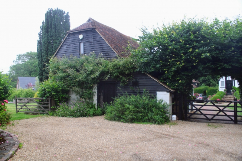
Barn 10 yards east of the
- Roundels
- II
Pre-1830 barn, weather-boarded with plain tiled, half-hipped roof. Catslide to
north. Reorted to have been used for the drying of malt and hops.
Listing NGR: TQ5875642614
External links are from the relevant listing authority and, where applicable, Wikidata. Wikidata IDs may be related buildings as well as this specific building. If you want to add or update a link, you will need to do so by editing the Wikidata entry.


Other nearby listed buildings
