Approximate Location Map
Large Map »
Latitude: 51.3905 / 51°23'25"N
Longitude: 0.3576 / 0°21'27"E
OS Eastings: 564129
OS Northings: 168359
OS Grid: TQ641683
Mapcode National: GBR NN4.M7L
Mapcode Global: VHJLR.49XV
Plus Code: 9F3299R5+62
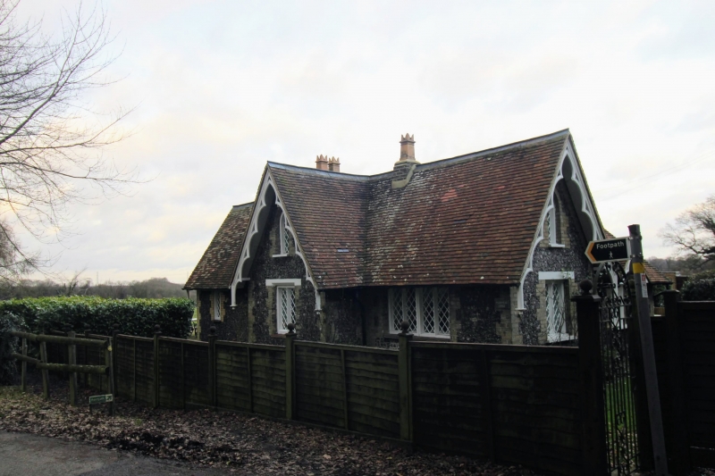
Entry Name: Nurstead Lodge
Listing Date: 26 July 1983
Grade: II
Source: Historic England
Source ID: 1350240
English Heritage Legacy ID: 356817
ID on this website: 101350240
Location: Nash Street, Gravesham, Kent, DA13
County: Kent
District: Gravesham
Civil Parish: Meopham
Traditional County: Kent
Lieutenancy Area (Ceremonial County): Kent
Church of England Parish: Nurstead St Mildred
Church of England Diocese: Rochester
Tagged with: Gatehouse
TQ 66 NW MEOPHAM NURSTEAD LANE
4/88
Nurstead Lodge
II
C19 "cottage orné". Knapped flint and brick. Tiled gabled roof with carved
bargeboards. One storey. Modern additions to north and east in keeping.
Listing NGR: TQ6412968359
External links are from the relevant listing authority and, where applicable, Wikidata. Wikidata IDs may be related buildings as well as this specific building. If you want to add or update a link, you will need to do so by editing the Wikidata entry.


Other nearby listed buildings
