Approximate Location Map
Large Map »
Latitude: 50.3618 / 50°21'42"N
Longitude: -4.1663 / 4°9'58"W
OS Eastings: 246010
OS Northings: 53570
OS Grid: SX460535
Mapcode National: GBR R6D.4X
Mapcode Global: FRA 2852.SSJ
Plus Code: 9C2Q9R6M+PF
Entry Name: Brewhouse, Royal William Victualling Yard
Listing Date: 13 August 1999
Grade: I
Source: Historic England
Source ID: 1378528
English Heritage Legacy ID: 476478
ID on this website: 101378528
Location: Cremyll, Plymouth, Devon, PL1
County: City of Plymouth
Electoral Ward/Division: St Peter and the Waterfront
Parish: Non Civil Parish
Built-Up Area: Plymouth
Traditional County: Devon
Lieutenancy Area (Ceremonial County): Devon
Tagged with: Brewery
SX 4653 NW
740-1/65/728
PLYMOUTH
CREMYLL STREET, Stonehouse
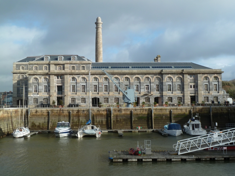
Brewhouse, Royal William Victualling Yard
GV I
Naval brewery and stores; water tank shed (from 1840), slaughterhouse and vegetable store (1885-1929), ordnance factory (1929), now disused. c1830-31, by Sir John Rennie Jnr, for the Victualling Board, tank shed added from 1840s, W range altered 1936, E range 1971. Grey limestone ashlar with granite dressings, tiled mansard roof, originally slate, wings have louvred ridge vents, cast-iron internal columns to timber floors. Late Georgian style.
PLAN: U-shaped with projecting NW brewhouse, central chimney, and central courtyard open to the SE, filled in from 1840s.
EXTERIOR: 2 storeys with 5 storey and attic NW block; 21-window NW range, 15-window sides with 4-window range returns, with 3-gable infill to SE. Original elevations have a granite plinth, low ground floor with banded rustication to a plat band, round-arched first-floor arcade linked by an impost band, and cornice and parapet; some original louvred tympana over later double casements, with small-paned metal tilting casements to the ground floor. NW elevation has central 5x3-window brewhouse block set 2 bays forward on open segmental arches, giant order 3 storey round-arched arcades with granite dressings, third- and fourth-floor segmental-arched windows with plain surrounds, the central full-height bay with iron-framed hoist doors; lower flanking ranges have doorways, partly altered, 3rd and 5th bays from the central block with double doors. The sides have central5-window sections recessed with central double doors, the outer sections have the centre bay defined by rusticated pilaster strips, with "BREWHOUSE" incised in a plat band to the S end of the NE elevation. Fine central round chimney has an entasis and a slightly flared cap. The central tank shed has 3 low rendered gables.
INTERIOR: the central brewhouse has a stone winder stair with iron balusters, and cast-iron posts with flanged pillows to beams; in the roof over the projecting section is a hoist frame, and part of the central section behind the chimney contains original columns. The two wings, originally floored, have a timber queen post roof.
HISTORY: although designed as a brewhouse, the beer ration was discontinued by the Admiralty in 1831 before the building was completed, and it remained largely unused until the transfer of the slaughterhouse in 1885. Water tanks were introduced into the Navy in 1813 and large numbers were required for the Fleet; the central yard was used for tank storage from before 1872, although it is not clear if the present infill building dates from then. Rennie planned an enclosed yard with railings and central gates to match those of the Old Cooperage opposite (qv). With the matching Mills and Bakery, and Melville (qv), forms the very fine seaward front to Royal William. The Yard is one of the most remarkable and complete early C19 industrial complexes, and a unique English example of Neo-Classical planning of a state manufacturing site.
(Sources: Keystone Historic Building Consultants: The Royal William Victualling Yard, Stonehouse: 1994: 79-101; Coad J: The Royal Dockyards 1690-1850: Aldershot: 1989: 288).
Listing NGR: SX4601053570
External links are from the relevant listing authority and, where applicable, Wikidata. Wikidata IDs may be related buildings as well as this specific building. If you want to add or update a link, you will need to do so by editing the Wikidata entry.


Other nearby listed buildings
