Latitude: 50.7899 / 50°47'23"N
Longitude: -1.1074 / 1°6'26"W
OS Eastings: 463015
OS Northings: 99308
OS Grid: SZ630993
Mapcode National: GBR VNG.64
Mapcode Global: FRA 87K0.4F4
Plus Code: 9C2WQVQV+X3
Entry Name: 18 Gun Battery and Flanking Battery, Kings Stairs, Sallyport, Pointbarracks
Listing Date: 30 October 1969
Last Amended: 18 March 1999
Grade: I
Source: Historic England
Source ID: 1386892
English Heritage Legacy ID: 474304
ID on this website: 101386892
Location: Old Portsmouth, Portsmouth, Hampshire, PO1
County: City of Portsmouth
Electoral Ward/Division: St Thomas
Parish: Non Civil Parish
Built-Up Area: Portsmouth
Traditional County: Hampshire
Lieutenancy Area (Ceremonial County): Hampshire
Church of England Parish: St Thomas of Canterbury, Portsmouth
Church of England Diocese: Portsmouth
Tagged with: Fortification
PORTSMOUTH
SZ6399 BROAD STREET, The Point 774-1/11/454 (West side) 30/10/69 18 Gun Battery & Flanking Battery, King's Stairs, Sallyport, Point Barracks (Formerly Listed as: BROAD STREET, The Point Square Tower Kings Stairs Sallyport 18 Gun Battery Round Tower Flanking Battery)
I
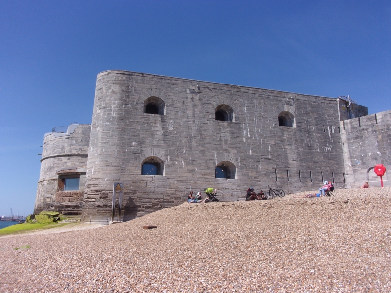
Fortifications, now monument. Eighteen Gun Battery and Flanking Battery. Late C17. By Sir Bernard de Gomme. Reconstructed 1847-50 when the casements were deepened and second tier of 3-gunports added to Flanking Battery. Ashlar stone with mid C19 brickwork in Flemish bond to north face and Flanking Battery. Roof-stone paved. 12 bays, 1-storey, Flanking Battery 2 storeys. Facing Broad Street, on left and at centre is a 2-leaf boarded door, each set under a segmental brick arch. Across front are 12 tunnel vaulted casements each with a round-headed stone gunport facing seaward (now blocked) set within a splayed recess with stone voussoir segmental arch, except fifth bay from north which has a late C18 Sallyport known as "The Common Sallyport" which replaced the gun port. In front of the fourth bay is a brick with stone stepped stairway to roof level, now promenade pedestrian way. The 4 casements on the right, each has a C20 boarded front infill, now toilets and store. Stone band over with stone capped parapet and attached railings. On right return is the 3 bay 2-storey Flanking Battery at right angles to the Round Tower (qv), each storey has 3 gun ports facing seawards. On left is a brick and stone stepped stairway to pedestrian level. Between Flanking Battery and Round Tower are 2 casements each with similar gun port to Eighteen Gun Battery. East of Eighteen Gun Battery is a short late C16 stone sea wall and further left the late C17 remains of the stone abutment to King James' Gate (demolished c1870 and re-erected in Burnaby Road) with open tunnel vaulted recess and boarded door on right set under a flat stone voussoir arch. Between former site of King James' gate and Square Tower (qv) is a late C16 stone firing platform, upper parts reconstructed in C20. On right is the late C18 "Old Sallyport" set under segmental stone arch which formerly had a stepped landing
stage known as "The Kings Stairs". Inscription reads "From this place naval heroes innumerable have embarked to fight their Country's battles. Near this spot Catherine of Braganza landed in state May 14 1662 previous to her marriage to Charles II at the Domus Dei a week later". To north-east of Round Tower is the Point Barracks 1847-50 in Flemish bond brickwork with 4 tunnel vaulted chambers. The east facing front half demolished C20. On left 34 stone steps lead to firing platform. To left of Point Barracks adjoining Round Tower and on far right is a 1-storey brick gallery with stone slab roof. (Balfour A: Portsmouth: London: 1970-: 18; Corney A: Fortifications in Old Portsmouth: Portsmouth City Museums: 1965-: 25-29; Lloyd DW: Buildings of Portsmouth and its Environs: Portsmouth: 1974-: 59; The Buildings of England: Pevsner N & Lloyd D: Hampshire and the Isle of Wight: Harmondsworth: 1967-: 422-424).
Listing NGR: SZ6292699463
External links are from the relevant listing authority and, where applicable, Wikidata. Wikidata IDs may be related buildings as well as this specific building. If you want to add or update a link, you will need to do so by editing the Wikidata entry.


Other nearby listed buildings