Approximate Location Map
Large Map »
Latitude: 54.3715 / 54°22'17"N
Longitude: -1.2984 / 1°17'54"W
OS Eastings: 445674
OS Northings: 497562
OS Grid: SE456975
Mapcode National: GBR MKCW.PP
Mapcode Global: WHD7Y.0DZ2
Plus Code: 9C6W9PC2+JJ
Entry Name: Pound
Listing Date: 24 July 2007
Grade: II
Source: Historic England
Source ID: 1392090
English Heritage Legacy ID: 502994
ID on this website: 101392090
Location: Osmotherley, North Yorkshire, DL6
County: North Yorkshire
District: Hambleton
Civil Parish: Osmotherley
Built-Up Area: Osmotherley
Traditional County: Yorkshire
Lieutenancy Area (Ceremonial County): North Yorkshire
Church of England Parish: Osmotherley St Peter
Church of England Diocese: York
Tagged with: Animal pound
OSMOTHERLEY
1438/0/10002 NORTH END
24-JUL-07 Pound
II
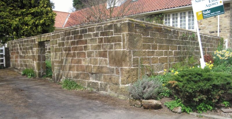
Village Pound or Pinfold, probably C18. Sandstone.
PLAN
The pinfold is a square enclosure with a single narrow entrance to the south.
EXTERIOR
The pinfold is constructed externally with tooled, coursed walling with quoins on edge and triangular coping. The entrance is spanned by a pair of dressed lintels.
INTERIOR
Internally the walls forming the pinfold are of rubble construction.
HISTORY
The pinfold is probably C18, possibly earlier and is shown on the 1857 1:10560 Ordnance Survey map and all subsequent editions.
SUMMARY OF IMPORTANCE
Pinfolds are a relic of medieval village administration and were designed to hold stray animals until their owners paid a fine for their release. Nearly all villages once had a pinfold, but well preserved surviving examples are becoming rare in a national context. The example in Osmotherley is well preserved and is constructed with relatively high quality stonework and thus fully meets the national criteria for listing. It has sufficient historical interest to merit listing in grade II.
External links are from the relevant listing authority and, where applicable, Wikidata. Wikidata IDs may be related buildings as well as this specific building. If you want to add or update a link, you will need to do so by editing the Wikidata entry.


Other nearby listed buildings
