Approximate Location Map
Large Map »
Latitude: 51.3991 / 51°23'56"N
Longitude: -1.6248 / 1°37'29"W
OS Eastings: 426199
OS Northings: 166742
OS Grid: SU261667
Mapcode National: GBR 5YX.B18
Mapcode Global: VHC1X.S3D8
Plus Code: 9C3W99XG+J3
Entry Name: Upper Horsehall Hill Farm
Listing Date: 12 August 2008
Grade: II
Source: Historic England
Source ID: 1392701
English Heritage Legacy ID: 505380
ID on this website: 101392701
Location: Wiltshire, SN8
County: Wiltshire
Civil Parish: Little Bedwyn
Traditional County: Wiltshire
Lieutenancy Area (Ceremonial County): Wiltshire
Tagged with: Agricultural structure
LITTLE BEDWYN
1643/0/10010 UPPER HORSEHALL HILL FARM
12-AUG-08
II
Also Known As: WELLHOUSE
WELL HOUSE
DESCRIPTION
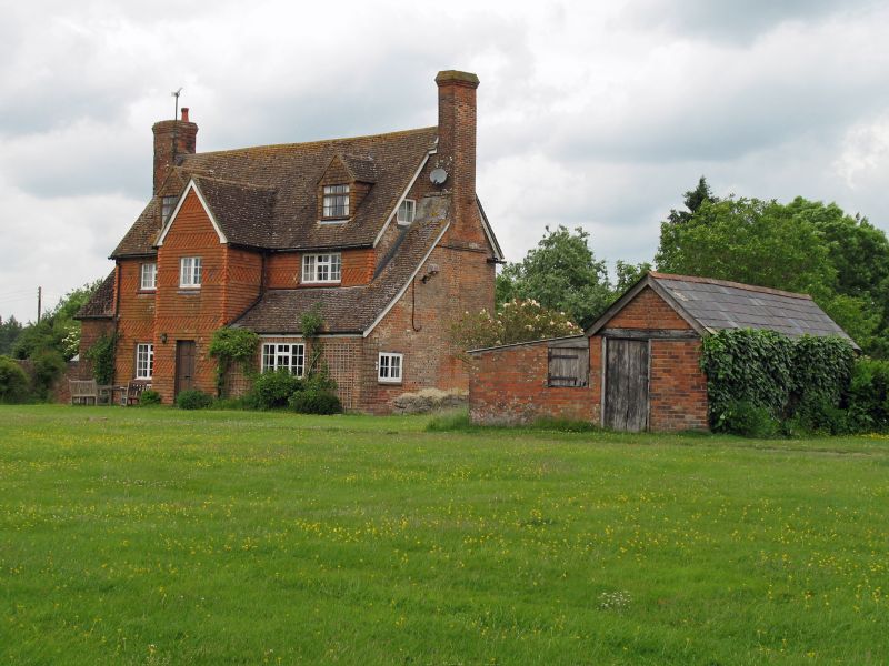
A vernacular house of late-C17/ early-C18 origin comprehensively reworked in the mid- to late-C18 with C19 and C20 alterations.
MATERIALS: The south elevation has decorative C19 tile hanging, though there are claims that some of the C19 tiles were re-hung in the C20. The rear elevation and gable ends are in English bond brick, probably dating from the mid-C18. The building has a pitched clay tile roof with full height external brick stacks. Attached to the west gable end is the remaining section of a former single storey extension, which contains a small section of timber framing at its north-west corner.
PLAN: A two storey house, three bays wide, with attic and a rectangular two room plan with a central staircase. The main entrance is now to the north, but may formerly have been to the south, where there is now a full height porch (probably added later).
EXTERIOR: The south elevation has three-light casement windows (late-C20) to both floors, and the central projecting porch has a central door (formerly a window) with a two-light casement window above. The right hand bay has a C19 brick lean-to, which appears to have been extended further southwards in the late C20. It abuts both the porch and the chimney stack on the east gable end. The attic has two full dormers, inserted in the late 1980s. The north elevation has a full length plat band with casement windows (C20) to both floors, and a small central entrance porch (late-C20) with a Britannia Firemark above it. Three flat brick lintels have survived above the windows and porch, suggesting it formerly had sash windows. Both gable ends are blind except for small single casement windows at attic level.
INTERIOR: In the hall is a narrow dogleg stair with square newel posts, turned vase balusters and ball finials (circa 1670). The roof, probably dating from the late-C17 or early-C18, is three bays wide with two trusses from principal rafters with collars, single purlins and paired common rafters. There is no ridge piece. There is vestigial evidence of straight wind braces, two surviving in the western half of the roof. The cuts of two further straight wind braces are visible in the purlin above the porch bay, indicating the latter was added at a later date than the current roof.
HISTORY
According to a survey report of 1991 by the Wiltshire Buildings Record (WBR), there is documentary evidence that there was a house at Upper Horsehall Hill at least since 1530, and that an inventory exists of 1592 which refers to the existence of a house with a kitchen. The WBR report suggests that the roof structure of the current house may date from this period, and that it was probably a timber framed, thatched house. Archival documents confirm that during the second half of the C17 the house was tenanted by a gentleman called John Thistlethwaite.
The current house is located at the end of the London Ride, a very long, straight ride that originates from the early-C18 (now disused, but traceable in the landscape) which extends in a north-easterly direction from Tottenham House. Its close proximity to Savernake Forest indicates that the site would have been situated within it: formerly the forest covered a much larger area than today.
The earliest available map evidence for a building at Upper Horsehall Hill dates from 1719 (Atkinson's map of the Manor of Chisbury). A building on this site is also shown on Andrew and Dury's Map of Wiltshire of 1773, marked as Horsell Hill. Greenwood's Map of Wiltshire of 1820 shows a building named as Horse Hill Farm. The Ordnance Survey maps of 1880, 1900 and 1924 indicate that the footprint of the current house remained unchanged. The 1880 map labels the building as Wellhouse. The OS map of 1900 indicates there was indeed a well in the grounds to the west of the house. Confusingly the cottage at nearby Lower Upper Horsehall Hill also appears to be labelled as Wellhouse on the historic OS maps, thus it is possible that this is referring to the function of a building on this site rather than to its name.
An aerial photograph of c1968 shows that Upper Horsehall Hill Farmhouse formerly had a single storey building or wing attached to its west. This is probably the building shown on the historic OS maps. It was demolished in the late 1970s.
In the late 1980s Upper Horsehall Hill Farm was sold by the Crown Estate. Subsequently various outbuildings were removed and the house itself was extensively refurbished.
SOURCES
A Map of `The Manour of Chisbury: For the Right Hon.ble Charles Lord Bruce', dated 1719, by T. Atkinson.
Andrew and Dury's Map of Wiltshire, 1773
Greenwood's Map of Wiltshire, 1820
Copies of annotated plans from 'A History of Savernake Forest', 1962 by the 7th Marquess of Ailesbury.
Ordnance Survey maps of 1880, 1900 and 1924.
Copy of an oblique aerial photograph of c1968/70 (private collection).
Wiltshire Buildings Record, A survey report of Upper Horsehall Hill Farm (1991).
DA Crowley (ed), A History of the County of Wiltshire: volume 16 (1999), p3.
REASONS FOR DESIGNATIONS:Upper Horsehall Hill Farm, near Chisbury in Wiltshire, merits designation on a national level for the following principal reasons:
* Despite the level of C20 alterations, the building is a good and interesting example of an evolved house with clear evidence of its development and continued upgrading to meet changing styles and/or gentrification.
* Its materials, such as its roof timbers, C18 brickwork and C19 tile hanging, are of good quality and add to the building's architectural interest.
* The C17 stair, despite its probable alterations and/or configuration, is a notable survival.
* Significant early map evidence, archival documentation, and its historically close proximity to Savernake Forest give the building considerable historic interest.
External links are from the relevant listing authority and, where applicable, Wikidata. Wikidata IDs may be related buildings as well as this specific building. If you want to add or update a link, you will need to do so by editing the Wikidata entry.


Other nearby listed buildings
