Approximate Location Map
Large Map »
Latitude: 51.5626 / 51°33'45"N
Longitude: 0.16 / 0°9'36"E
OS Eastings: 549820
OS Northings: 187069
OS Grid: TQ498870
Mapcode National: GBR RR.906
Mapcode Global: VHHN6.QZGH
Plus Code: 9F32H576+22
Entry Name: Coal Duty Boundary Marker
Listing Date: 1 November 2013
Grade: II
Source: Historic England
Source ID: 1416560
ID on this website: 101416560
Location: Becontree Heath, Barking and Dagenham, London, RM10
County: London
District: Barking and Dagenham
Electoral Ward/Division: Heath
Parish: Non Civil Parish
Built-Up Area: Barking and Dagenham
Traditional County: Essex
Lieutenancy Area (Ceremonial County): Greater London
Church of England Parish: Romford St Augustine of Canterbury
Church of England Diocese: Chelmsford
Tagged with: Coal-tax post Coal duty marker
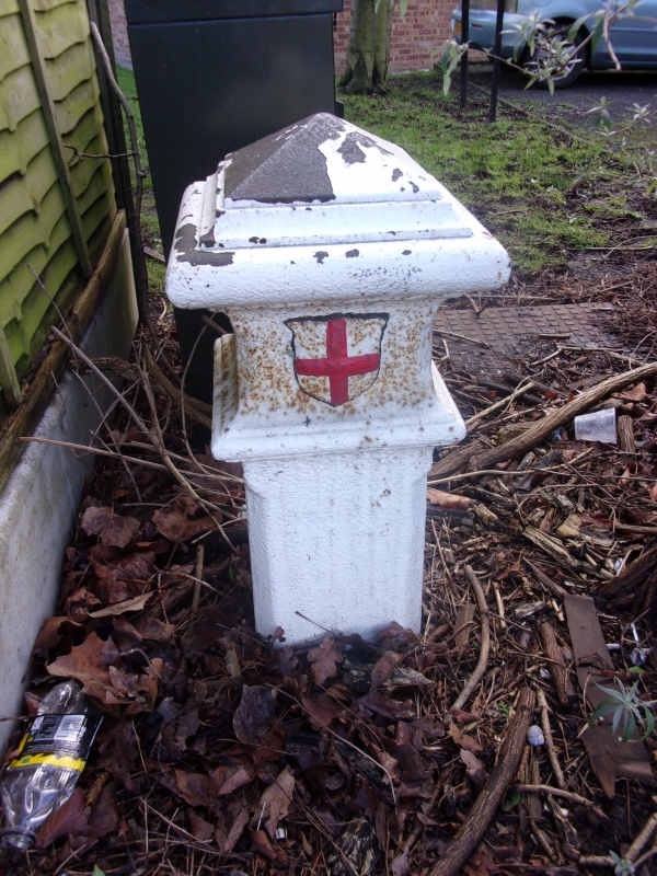
Coal Duty boundary marker. Erected c1881.
MATERIAL: cast iron, painted white.
DESCRIPTION: between 1.2m and 2m in total height but the post is deeply buried with only around 650mm showing above ground. It is square in plan with chamfered corners and a pyramidal cap. The front face bears a raised shield from the City of London’s Arms with a red painted cross, set between roll mouldings at the top of the post. Below the lower moulding, the Act citation ‘ACT 24 & 25/ Vict Cap 42’ is just legible.
Taxes had been levied on the importation of coal into the City of London since the medieval period and various successive Acts of Parliament allowed the City to spend the proceeds on public works, notably rebuilding St Paul’s Cathedral and the City Churches after the Great Fire of 1666. Originally, nearly all coal arrived by ship at the port of London and was taxed at the point of embarkation but by the C19 it was increasingly transported overland by canal and rail. Under the Coal Duties (London and Westminster and Adjacent Counties) Act of 1851, Coal Duty markers were erected around London to mark the point where duty became payable. This boundary had been established by the Coal Duty, London Act of 1845 at a distance of 20 miles from the General Post Office. The London Coal and Wine Duties Continuance Act of 1861 established the Metropolitan Police District plus the City of London as the new boundary and around 280 standardised cast-iron markers were installed to mark it. The duty on coal was finally abolished in 1889.
The cast iron Coal Duty Boundary Marker on Wood Lane, Dagenham, erected c1861, is listed at Grade II for the following principal reason:
* Historic interest: as a tangible reminder of the tax on coal imported into London from the medieval period until its abolition in 1889. It also marks the position of the Metropolitan Police District boundary when erected in 1861.
External links are from the relevant listing authority and, where applicable, Wikidata. Wikidata IDs may be related buildings as well as this specific building. If you want to add or update a link, you will need to do so by editing the Wikidata entry.


Other nearby listed buildings
