Approximate Location Map
Large Map »
Latitude: 50.9232 / 50°55'23"N
Longitude: -2.7507 / 2°45'2"W
OS Eastings: 347330
OS Northings: 114013
OS Grid: ST473140
Mapcode National: GBR MJ.Q0YB
Mapcode Global: FRA 564N.L6B
Plus Code: 9C2VW6FX+7P
Entry Name: Direction stone at the junction of Smith's Hill and Smoky Hole Lane
Listing Date: 20 September 2019
Grade: II
Source: Historic England
Source ID: 1466289
ID on this website: 101466289
Location: West Chinnock, Somerset, TA18
County: Somerset
District: South Somerset
Civil Parish: West and Middle Chinnock
Built-Up Area: West Chinnock
Traditional County: Somerset
Lieutenancy Area (Ceremonial County): Somerset
Tagged with: Stone Guidestone
Mid-C18 direction stone to the north of Middle Chinnock village at the junction of Smith’s Hill and Smoky Hole Lane.
Mid-C18 direction stone to the north of Middle Chinnock village at the junction of Smith’s Hill and Smoky Hole Lane.
MATERIALS: Ham stone.
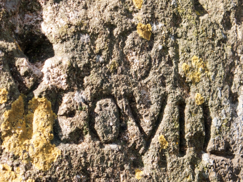
DESCRIPTION: a direction marker dating from 1745 with pointing hands cut into the stone surface. The stone is approximately 130cm high, tapering from 36cm by 30cm at its base to 33cm by 28cm at the top. The hands indicate the direction to named principal destinations; the distances are not included. On the south face of the stone the upper inscribed cuffed hand points east to EAST / NNICK (believed to be East Chinnock). Below, another hand points west to CREWKE/RNE ROAD. On the east face another cuffed hand points north above the inscription YEOVIL / ROAD with a further illegible word below. Below this is a date which appears to read 1745.
Finding the way has always been a fundamental part of long distance travel. While local people would know which way to turn at a cross roads or junction, a stranger would not. The matter was addressed by central Government in 1697 in an Act of Parliament; this authorised local Justices of the Peace to instruct highway surveyors to put up a direction stone or post ‘for the better convenience of travelling in such Parts of the Kingdome which are remote from Towns and where several Highways meet.’ Further Acts followed and it was normal for parish highway surveyors to erect wooden fingerposts at crossroads when instructed to do so. Wooden fingerposts had a limited life, so a few parishes chose the more enduring, but more expensive, stone direction posts.
The John Ogilby strip maps, dating to around 1675, include one for a road from Weymouth to Bristol. Two and a half miles north of Crewkerne, the map shows that the route turned east at Bow Gate (on the present A356) and crossed Bow Bridge. The route continued north through the village of West Chinnock where, at its northern edge, the map shows a junction indicating ‘to Euil’ (an early spelling for Yeovil); this road is now known as Smith’s Hill. The map therefore persuaded travellers heading for Yeovil to turn east at this point. The direction stone was located at the eastern end of Smith’s Hill where it directs traffic to turn up Smoky Hole Lane to follow higher and firmer ground which required less maintenance as, before the introduction of turnpike roads (none of the roads through West Chinnock were ever turnpiked), the local parish was responsible for the maintenance of the roads in its area. The direction stone may have been added in around 1745 as a result of the 1670s map. It also directed travellers east towards East Chinnock, a road that today continues after Eastfield Farm as a public footpath. The stone is shown on the 1887 and later Ordnance Survey maps of Somerset (1:2500 and 1:10560) but does not appear to be depicted on any county maps predating 1745.
The section of the A356 from Crewkerne north towards Martock was turnpiked following the Crewkerne Trust’s first Act of 1765, and therefore avoiding the turn at Bow Gate. An alternative direct route from Crewkerne to Yeovil was first turnpiked following the Yeovil Act of 1753. The need for a direction stone at the corner of Smith’s Hill and Smoky Hole Lane was therefore relatively short-lived.
In August 2018 the stone was excavated and reset in the same position, during which time it was discovered that it was much longer than expected (2286mm).
The mid-C18 direction stone to the north of Middle Chinnock village at the junction of Smith’s Hill and Smoky Hole Lane is listed at Grade II for the following principal reasons:
Historic interest:
* as a representation of signposting on rural routes before the General Turnpike Act of 1773;
* for the etymological interest of the early spelling of Yeovil
* as one of a range/collection of the same type and date in this part of Somerset.
Architectural interest:
* for the added artistic touch of cuffed, pointing hands.
External links are from the relevant listing authority and, where applicable, Wikidata. Wikidata IDs may be related buildings as well as this specific building. If you want to add or update a link, you will need to do so by editing the Wikidata entry.


Other nearby listed buildings