Approximate Location Map
Large Map »
Latitude: 51.2408 / 51°14'27"N
Longitude: -0.0564 / 0°3'23"W
OS Eastings: 535768
OS Northings: 150868
OS Grid: TQ357508
Mapcode National: GBR KKJ.4K7
Mapcode Global: VHGSC.Z21L
Plus Code: 9C3X6WRV+8C
Entry Name: Milestone 21 on the the south side of Eastbourne Road (B2236) near the junction with Church Lane, Godstone
Listing Date: 22 July 2021
Grade: II
Source: Historic England
Source ID: 1472098
ID on this website: 101472098
Location: Church Town, Tandridge, Surrey, RH9
County: Surrey
District: Tandridge
Civil Parish: Godstone
Traditional County: Surrey
Lieutenancy Area (Ceremonial County): Surrey
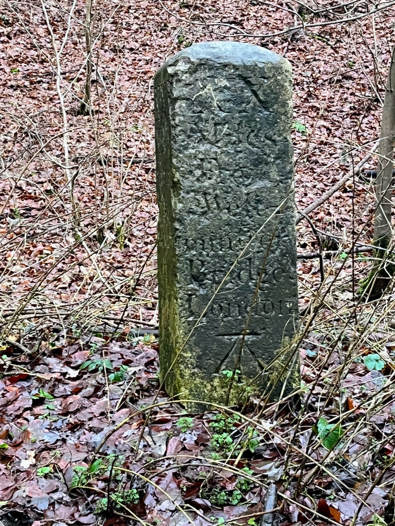
A milestone of around 1744 marking 20-21 miles from London, on the former Eastbourne Road.
A milestone of around 1744 marking 20 to 21 miles from London, on the former Eastbourne Road.
MATERIALS: stone.
DESCRIPTION: the rectangular milestone stands on the south side of the B2236 near its junction with Church Lane. The milestone is around 1m in height and 0.25m in width. It is carved from a single piece of stone, has straight sides and terminates in a shallow, chamfered cap. Three faces are inscribed; two read: 'XXI MILES FROM THE STANDARD IN CORNHILL, LONDON - 1744', the other 'XX MILES FROM WESTMINSTER BRIDGE LONDON' along with a carved benchmark.
Milestones, along with mileposts and guideposts, are one of the most widespread forms of street furniture. Roads undergo such considerable alteration that they can be of particular note as testaments to the development of our transport network, and as reminders of the different perceptions of distance in a pre-motorised age. Initially they were carved out of stone and a variety of forms are still evident around the country.
Many important routes across Surrey were created or enhanced in the C18 or C19 to facilitate longer-distance overland travel at a toll charge. New and improved roads required new infrastructure like bridges and causeways, as well as milestones to inform travellers of relevant distances. Most were created and maintained by turnpike trusts, bodies established by Acts of Parliament that collected tolls from road users. From 1767, mileposts were compulsory on all turnpikes, not only to inform travellers of direction and distances, but to help coaches keep to schedule and for charging for changes of horses at the coaching inns. The distances were also used to calculate postal charges before the uniform postal rate was introduced in 1840. At the height of the turnpike era, there were 20,000 miles of roads with milestones.
Milestone 21 was erected by the Godstone and Highgate Turnpike Trust as part of a series of trusts providing a route from London to Eastbourne. It is inscribed with the date 1744 and identifies the distance to both the Cornhill Standard in the City of London (21 miles) and Westminster Bridge (20 miles). The turnpike was diverted in the C19 because the original route included Tilburstow Hill, causing a problem for traffic in inclement weather. The C18 Rocque map shows a milestone on the hill, but not at the current location of milestone 21.The Ordnance Survey map of 1869 shows a milestone marking 20 miles to Westminster at milestone 21's current location. Given the date inscription it is probable that it was relocated around 1840, when the route was altered.
There are nine other Grade II-listed milestones on the London to Eastbourne route. Two stone milestones further north dated 1744, another outside 362 Godstone Road, Kenley (around 15 miles from London) and two wooden examples at around 35 miles south-east of London. A further four in the sequence stand further south from Milestone 21 (milestones 22-25). Because of bypassing work over time, others may exist on what are now B roads.
Milestone 21 of around 1744, marking 21 miles from London, on the former Eastbourne Road is listed at Grade II for the following principal reasons:
Architectural interest:
* as a mid-C18 example of a stone milestone, retaining its original form and lettering.
Historic interest:
* milestone 21 is an increasingly rare example of the many milestones that were erected to manage the operation of a network of independent C18 and C19 turnpikes, connecting London to the South Coast.
Group value:
* with the nine other Grade II-listed milestones on the route from London to Eastbourne, which collectively form a legible sequence, including examples of differing materials, styles and dates.
External links are from the relevant listing authority and, where applicable, Wikidata. Wikidata IDs may be related buildings as well as this specific building. If you want to add or update a link, you will need to do so by editing the Wikidata entry.


Other nearby listed buildings