Approximate Location Map
Large Map »
Latitude: 50.3331 / 50°19'59"N
Longitude: -4.7578 / 4°45'28"W
OS Eastings: 203829
OS Northings: 51771
OS Grid: SX038517
Mapcode National: GBR N1.XFNW
Mapcode Global: FRA 08X5.47V
Plus Code: 9C2Q86MR+7V
Entry Name: Former copper-ore storage floor and boundary walls
Listing Date: 4 February 2022
Grade: II
Source: Historic England
Source ID: 1478672
ID on this website: 101478672
Location: Charlestown, Cornwall, PL25
County: Cornwall
Civil Parish: St Austell Bay
Built-Up Area: St Austell
Traditional County: Cornwall
Lieutenancy Area (Ceremonial County): Cornwall
Former copper-ore storage floor, mid-C18; with a boundary and dividing wall which are probably mid-C19.
Former copper-ore storage floor, mid-C18; with a boundary and dividing wall which are probably mid-C19.
PLAN: the former ore floor is located on the east side of Charlestown Road on the approach to the harbour. It is bounded to the south by Duck Street, to the east by a sharp bend in Quay Road, and to the north by the Rashleigh Arms and the buildings to its east. The main entrance is on the west side, although there is pedestrian access to the south from Quay Road.
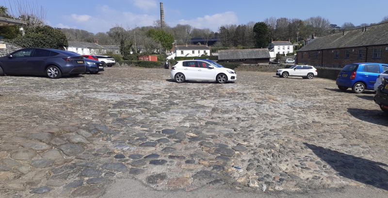
DESCRIPTION: the ore floor is an extensive area (approximately 2,000 square-metres) floored with a geological variety of rough cobble stones, fixed in a mixture of earth and gravel with some areas of concrete.
It is enclosed with rubble-stone walls around 1.5m high, some with modern concrete coping. On the outer face on the east and west sides are recesses with worked granite surrounds which housed water taps. A subdividing wall of granite masonry is located approximately two-thirds of the distance from the entrance to the floor (in the location as shown on the 1930s OS) which has a wide central opening.
The village of Charlestown was developed from two farms, Higher and Lower Polmear, from 1784 under the direction of Charles Rashleigh, a son of the Rashleighs of Menabilly. The deep-water harbour, commissioned from John Smeaton in 1792, was the export-focus of the principal industries in the area: pilchard fishing, copper mining, and china-clay and stone extraction. Copper and clay were heavy products with no end use in the county, so they were exported by sea to South Wales and the Staffordshire Potteries respectively, and pilchards to Catholic Mediterranean countries. Imports included coal, timber and other products to support the copper mining industry at nearby sites such as Appletree, West Crinnis and Wheal Regent less than a mile to the north-east, and Polgooth further inland to the north.
Before the construction of the harbour, small-scale import and export was conducted at the beach at Lower Polmear. Ships were run up the beach at high tide, loaded directly from horse-drawn wagons, and were floated off on the flood. This was risky and placed a constraint on the amount that could be exported from the growing extractive industries. When Rashleigh purchased Polmear its population was nine people, and comprised a farm, a few cottages and a fish cellar. Rashleigh’s harbour enabled the pilchard industry to flourish, and the added infrastructure of rope walks, limekilns, and storage for copper ore on floors and in hutches, alongside the growth of the settlement itself to cater for the workforce, resulted in a flourishing port by 1823, the year of Rashleigh’s death. By 1851 the population was 2,871.
The copper ore was cleaned and crushed at the nearby mine and was brought to Charlestown by horse and cart. It was tipped onto ore floors in 10-tonne piles (or ‘doles’) where it was stored prior to being sampled by an assayer who would determine the copper content. Smelting company representatives would check for any smelting problems, and then at meetings (known as ‘ticketings’) the bids for each pile from the companies would be submitted. Once the piles of ore had been purchased by the successful bidders it was moved to ore hutches at the quayside for transfer onto ships for export. The copper-ore floors were areas of land from which the topsoil had been removed. As extraction and therefore demand grew, they were covered with purpose-built stone surfaces; this improved the quality of the ore and also provided better access. Any stone that was convenient and to hand was used to dress the floors: at the Rashleigh Arms ore floor there are traces of limestone left over from that imported for lime-burning, and stone alien to the area likely to be discarded ballast of incoming ships; it has been identified as stone from Plymouth, Scotland, Scandinavia and France.
Copper-ore storage floors in Charlestown are likely to have been in use since the mid-C18; a detailed survey of Charlestown in 1825 by Richard Thomas of Falmouth records four ore floors, including one to the south of a coal yard on the east side of Charlestown Road, the site of the Rashleigh Arms. Historically probably covering an area of around 2,300 square-metres (24,751 square feet), the 1839 Tithe map for Charlestown shows the ore floor with its west and east sides angled eastwards; a dotted line depicting the boundary suggests that it was not enclosed. The Tithe apportionment records the ore floor along with others, plus ‘china clay floors, roads, wastages, pier, basins’ as being owned by the Charlestown Shipping Company. The 1881 Ordnance Survey (OS) (1:2500) shows the ore-storage floor as a roughly-rectangular open area to the south of the Rashleigh Arms Hotel and the buildings to its east. The west boundary to Charlestown Road is angled slightly inward, and the east boundary to Quay Road is slightly curved around from north to south. At the south-west corner is a small structure. The 1905 OS shows the floor with the same boundary shape, but by this date the space had been subdivided into three roughly-equal areas. Two water taps are labelled on the boundary to the ore floor. An additional small building is shown to the east of the structure in the south-west corner. To the west it appears that a forecourt or footway had been added to protect the activity on the east side of Charlestown Road from traffic. By the time of the 1936 OS one of the dividing walls had been removed and the small structure at the south-west corner is not shown. At some point the eastern section of the ore floor may have been used as a coal yard. The former ore-storage floor has been used by the Rashleigh Arms public house as a car park for many years; it is now also used as a public car park. A gig-boat shed was constructed at the south-east corner of the ore floor in 2011-12 (not included in the listing).
The former copper-ore storage floor and boundary walls at Charlestown, Cornwall are listed at Grade II, for the following principal reasons:
Historic interest:
* for its relationship to the early industrial development of Charlestown;
* as part of the integrated infrastructure of the copper-ore export industry;
* constructed from a varied collection of cobbles of differing geological provenance, providing evidence of historic trade routes from the harbour.
Architectural interest:
* the ore floor is an early example of an industrial structure within Charlestown as it began to flourish from the late C18, and is the last of several to survive;
* a visually distinctive surface, composed of various large cobbles which add variety and colour, which together with the later-C19 the boundary walls illustrate a key stage of the copper-ore export industry in Charlestown.
Group value:
* with numerous other nearby listed buildings, and its functional connection to the Grade II*-listed harbour.
External links are from the relevant listing authority and, where applicable, Wikidata. Wikidata IDs may be related buildings as well as this specific building. If you want to add or update a link, you will need to do so by editing the Wikidata entry.


Other nearby listed buildings