Approximate Location Map
Large Map »
Latitude: 51.3836 / 51°23'1"N
Longitude: 0.5152 / 0°30'54"E
OS Eastings: 575118
OS Northings: 167956
OS Grid: TQ751679
Mapcode National: GBR PPV.C13
Mapcode Global: VHJLT.WH65
Plus Code: 9F329GM8+F3
Entry Name: The Cottage
Listing Date: 26 September 2022
Grade: II
Source: Historic England
Source ID: 1479148
ID on this website: 101479148
Location: Chatham, Medway, Kent, ME1
County: Medway
Electoral Ward/Division: River
Built-Up Area: Chatham
Traditional County: Kent
Lieutenancy Area (Ceremonial County): Kent
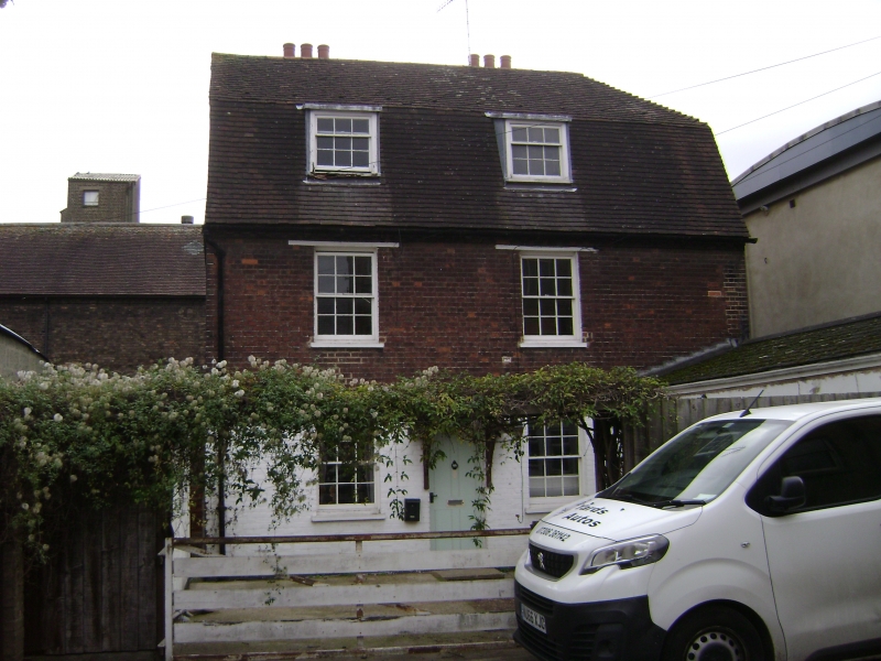
A semi-detached pair of cottages, now a single dwelling, probably built in the late C18 or early C19 and certainly by 1843 on land originally owned by St Bartholomew's Hospital.
A semi-detached pair of cottages, now a single dwelling, probably constructed by 1835 and certainly by 1843.
MATERIALS: walls of red brick laid in Flemish bond; roof covered with Kent peg tiles and with natural slate to the north gable end; sash windows of painted timber.
PLAN: the principal building is rectangular on plan, forming an L-shape with a single-storey, C20 extension to the south of the front yard. The extension is on the footprint of an earlier range shown on the 1843 tithe map and subsequent OS maps, but has been largely rebuilt and is therefore of lesser interest. The building is positioned between Ship Lane and Cooks Wharf, oriented towards the latter. It was originally a pair of semi-detached cottages, now combined into a single dwelling. Each cottage had an identical plan: one room per floor, with fireplaces positioned centrally on the rear wall and a corner staircase adjacent. This plan survives largely unaltered: a single doorway inserted into the party wall connects the two ground-floor rooms and the original front door to the southernmost cottage is now an internal doorway leading into the single-storey extension.
EXTERIOR: the principal building has two storeys plus an attic floor in the gambrel roof. The front elevation faces west towards Cooks Wharf overlooking a small yard. The external walls are constructed from red brick laid in Flemish bond, limewashed at ground-floor level to the west elevation. There are two windows per floor to this elevation: pairs of six-over-six sashes to the ground and first floors, with projecting sills, and a pair of three-over-six sashes in raking dormers to the attic floor. All the windows have narrow, moulded glazing bars. The ground-floor windows have cambered arches of brick while those to the first floor have timber lintels with a simple brick dentil cornice above. Positioned between the two ground-floor windows is the front door, which would originally have served just the north cottage. The four-panelled door is sheltered by a tiled gablet of timber supported on timber brackets.
The side and rear elevations are blind. The north and south side elevations have brickwork rendered with black limewash. The rear elevation to Ship Lane has a simple brick dentil cornice interrupted by two brick chimney stacks that rise above the height of the roof ridge, each with a single string course of brick towards the top. The base of this elevation has a batter of five or six stepped courses of brick. The south slope of the roof is half-hipped while the north end is gabled and hung with natural slates. The base of the south elevation has a stone plinth that continues halfway across the single-storey extension to the front elevation, which has rendered external walls, probably concrete, and a mono-pitched roof* covered with tiles. It has a single door and three casement windows* to its north elevation.
INTERIOR: the principal building has two rooms per floor. Each room has a single window to its west wall and, to its east wall, a fireplace flanked by a cupboard and a doorway to the staircase. The south ground-floor room has simple, timber panelling up to the moulded dado. The fireplace is boxed-in but a panel above the mantel-shelf is exposed, revealing a stack of red brick laid in English bond and a segmental arch of brick beneath a timber lintel. The north ground-floor room has a moulded dado rail and skirting. There is a cast iron fireplace with blue tiles and a timber mantel-shelf supported by moulded consoles. Both ground-floor rooms have original doors and panelling to the cupboards either side of the fireplaces, and matching doors leading to the adjacent winder staircases.
The first-floor bedrooms have each had a canted partition wall with a doorway inserted in front of the respective staircases to create a landing. Originally each flight of stairs would have had doors at the top and bottom that opened straight into each room with no landing. Timber panelling around the doors to both staircases survives at this level. The south first-floor room has a moulded chimneypiece of timber, but the fireplace has been boxed in. The north first-floor room has an arched fireplace of cast iron with floral mouldings, a tiled surround and a moulded chimneypiece of timber. Both first-floor rooms have simple, moulded dado rails and skirting boards and an in-built cupboard to the north of each fireplace.
The doorway at the top of the south staircase opens straight into an attic bedroom. Like other rooms this room has a timber fire surround and a fireplace of cast iron to one side of the door. On the other side of the fireplace is an in-built cupboard. The north attic bedroom was not inspected.
The C20 single-storey extension is accessed internally via what would have been the front door for the southernmost cottage. The extension contains a kitchen*, bathroom* and toilet*, all modern in character.
SUBSIDIARY FEATURES: extending from the north end of the rear elevation there is a boundary wall of red brick laid in Flemish bond topped with a row lock course. The wall extends along Ship Lane approximately to where the edge of the group of three other tenements previously stood to the north of The Cottage. The southern part of the top of the wall has been built up with concrete blocks at a later date, and the northern part is topped with corrugated metal which forms the rear wall of an adjacent industrial building.
* Pursuant to s1 (5A) of the Planning (Listed Buildings and Conservation Areas) Act 1990 (‘the Act’), it is declared that these aforementioned features are not of special architectural or historic interest, however any works which have the potential to affect the character of the listed building as a building of special architectural or historic interest may still require LBC and this is a matter for the LPA to determine.
The building now known as The Cottage was originally a pair of semi-detached cottages. It was probably built in the late C18 or early C19 on land that was originally part of the St Bartholomew’s Hospital Estate. A map of the area from 1806 shows some buildings between Cooks Wharf and Ship Lane in the approximate position of The Cottage but it is not clear if they depict the extant building. The pair of cottages are clearly shown on the 1843 Chatham Parish Tithe Map with front yards on the west side, and so had definitely been constructed by that date. The southernmost cottage appears to have had a narrow front wing or extension occupying half of the yard. A single-storey extension with a similar footprint stands in the same position on the present site but has clearly been rebuilt since the 1843 map. The original extension probably housed a privy and possibly stores and a wash house, as neither cottage had a back yard. The 1843 map and Ordnance Survey (OS) up to and including the 1909 map show a similar extension to the north elevation of The Cottage, which may have had a similar function for the other dwelling. The cottages were separated from three other tenements by a small yard to the north, and two further pairs of tenements stood to the east on the opposite side of Ship Lane. These tightly-packed tenements, along with No 9 Wharf and a coal storehouse, appear by 1835 to have been leased by the Hospital to James Cook, a local coal merchant and the probable source of the name of Cooks Wharf. A photograph taken around 1900 looking south along Ship Lane shows the street lined with mostly two-storey buildings with attics of timber construction, with one of the brick chimney stacks of The Cottage visible in the background. In contrast to these timber-clad houses, the brick construction of The Cottage marks it out as a slightly higher status back lane dwelling. The other houses in Ship Lane and Cooks Wharf visible in the photograph and the 1843 map were all demolished in the mid-C20.
Historic OS maps appear to show that the building remained a distinct pair of cottages until the publication of the 1955 OS map, which shows a single L-shaped building labelled as The Cottage. To convert the building to a single dwelling an internal doorway was created in the party wall to provide access between the two ground-floor rooms, but the original plan remains otherwise unchanged with two corner staircases leading to the upper floors. This arrangement of one room per floor with a corner staircase was probably quite prevalent in other back lane houses off Chatham Intra and also survives in the almshouses of the nearby Hospital of Sir John Hawkins built in 1789 (NHLE: 1268233; Grade II). A detached, single-storey outbuilding was added to the north side of The Cottage's front yard in the second half of the C20.
In the Domesday Book Chatham was called Ceteham, which derives from ‘cyte’ (the Saxon word for cottage) and ‘ham’ (village): in other words, ‘Village of Cottages’. The name Chatham Intra is associated with an area of sloping land extending down to the river Medway that links the historic settlements of Rochester and Chatham. This middle ground was split administratively between the two towns and straddled three parishes. A misalignment of the civil and ecclesiastical boundaries led to the designation of part of the area as Chatham Intra (i.e. that part of Chatham parish within the City of Rochester) but the name came to be more widely applied.
The area was traversed by an ancient routeway running between London and Canterbury and onward to Dover, of Roman or earlier origin. This evolved into a continuous High Street running from Strood to Chatham that provided the initial focus of the linear development of Chatham Intra. This got underway with the construction of the Hospital of St Bartholomew for people with leprosy in 1078, located at the edge of the City of Rochester’s boundary. This charitable foundation, whose much altered chapel remains, re-emerged in 1861-3 when a substantial new hospital of the same name was built nearby.
From the C17 development in Chatham Intra arrived from the west, as part of Rochester’s suburban expansion along the higher ground above the marshy riverside that produced St Margaret’s Banks. And from the east, as the modest settlement of Chatham underwent significant expansion following the establishment of the naval dockyard in the late C16. Thereafter its fortunes were tied to the military, as a garrison town and naval base serving the needs of soldiers, sailors and marines until the late C20. This also brought Jewish tradesmen to the area, some of whom went on to make an important contribution to Chatham and the Medway region. Some of the earliest developments within Chatham Intra were undertaken by men with naval associations on land owned by St Bartholomew’s Hospital, including Sir John Hawkins and the Pett family. The almshouses for sailors established by Hawkins in the 1580s survive albeit rebuilt in 1789. But the only naval facility to be located in Chatham Intra, a Victualling Yard, ceased operation in the 1820s.
From the C18 the area began to develop an increasingly commercial and industrial character, including ship-building, brewing and the movement of goods, notably coal and timber. This encouraged the building up of wharves and piers and a process of encroachment into the river Medway that reached a peak in the early C20. The riverside development was connected to the increasingly built-up frontage of the High Street by narrow lanes lined with cottages and small houses. As expansion uphill on the south side of the street was encouraged by the opening of New Road in early 1770s. Further impetus came from the railways, which arrived at Strood in 1845 and crossed the Medway in 1853, requiring the construction of a viaduct across Chatham Intra that enabled for the exploitation of the remaining marshland. Commercial development along the High Street was given a boost by the rebuilding necessitated by two major fires in 1800 and 1820. Subsequently pursued by landowners seeking to build more densely but also to enable road widening along what had become a congested thoroughfare.
The Cottage, constructed by 1843, is listed at Grade II for the following principal reasons:
Architectural interest:
* as a pre-1850 dwelling, The Cottage retains a significant proportion of original fabric;
* the modest single-room corner-staircase plan survives in each of the two original dwellings, and a good level of historic joinery, fixtures and fittings survive throughout the interior;
* the modest but good-quality brick construction marks out The Cottage as a slightly higher-status dwelling than the other domestic buildings that would previously have stood around it.
Historic interest:
* the orientation and construction of the building serves to illustrate the broader pattern of lane development between Chatham Intra and the River Medway from the C18 onwards;
* Rarity: as one of few surviving examples of the types of domestic dwelling constructed along the back lanes and wharves north of Chatham Intra in the C18 and early C19.
Group value:
* with other nearby listed houses of C18 and C19 origin, namely: the House at Rear of No 321 High Street (NHLE: 1116093; Grade II); 329, 331, 333 and 335 High Street (NHLE: 1336147; Grade II); 343 and 345 High Street (NHLE: 1116104; Grade II); and 351 High Street (NHLE: 1320136; Grade II*).
External links are from the relevant listing authority and, where applicable, Wikidata. Wikidata IDs may be related buildings as well as this specific building. If you want to add or update a link, you will need to do so by editing the Wikidata entry.


Other nearby listed buildings