Approximate Location Map
Large Map »
Latitude: 52.8309 / 52°49'51"N
Longitude: -4.532 / 4°31'55"W
OS Eastings: 229519
OS Northings: 328930
OS Grid: SH295289
Mapcode National: GBR 55.TPL9
Mapcode Global: WH44V.C34M
Plus Code: 9C4QRFJ9+85
Entry Name: Siop Llangian
Listing Date: 19 October 1971
Last Amended: 1 April 1998
Grade: II
Source: Cadw
Source ID: 4311
Building Class: Commercial
ID on this website: 300004311
Location: Situated in centre of Llangian on corner of road to Botwnnog.
County: Gwynedd
Town: Pwllheli
Community: Llanengan
Community: Llanengan
Locality: Llangian
Traditional County: Caernarfonshire
Tagged with: Architectural structure
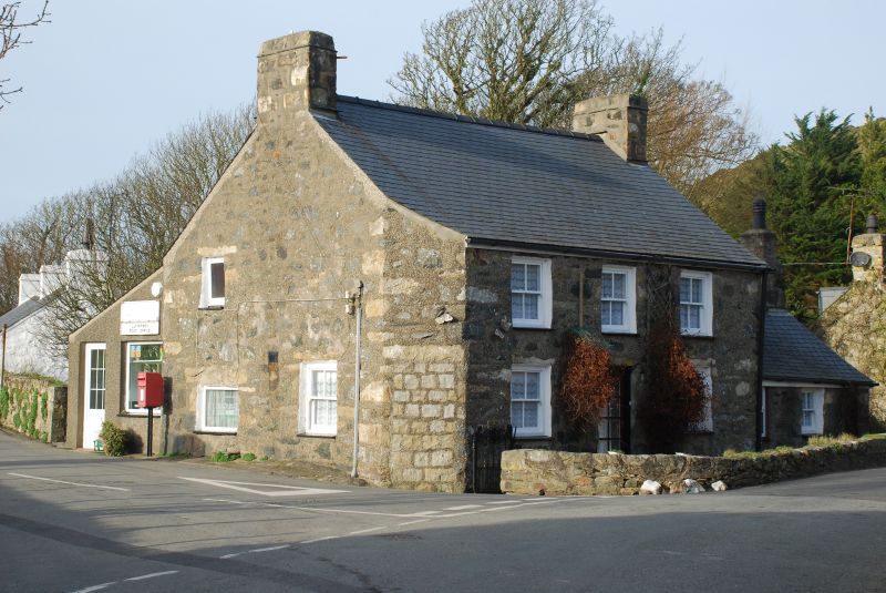
Mid C19 house and shop, identified as Shop Llangian on a gravestone of 1849 in Llanengan churchyard of a child of Henry Jones 1811-92 and Mary Jones 1809-82.
House, formerly with integral shop, shop now in added rear lean-to. Rubble stone with slate close-eaved roof and stone end stacks. Two-storey, 3-window range of 4-pane horned sashes and centre C20 glazed door (former door had overlight). Slate sills, stone slab lintels. SE corner is splayed with former shop door now blocked, also with slab lintel. S end has small window each floor to left, larger 4-pane sash to ground floor right. N end has small single storey outbuilding with N end stack, C20 window and 4-pane sash.
Earlier C20 lean-to shop on rear, pebbledashed, with S end door and shop window.
Included for group value with other listed items in Llangian village.
External links are from the relevant listing authority and, where applicable, Wikidata. Wikidata IDs may be related buildings as well as this specific building. If you want to add or update a link, you will need to do so by editing the Wikidata entry.


Other nearby listed buildings
