Approximate Location Map
Large Map »
Latitude: 52.8618 / 52°51'42"N
Longitude: -3.6771 / 3°40'37"W
OS Eastings: 287184
OS Northings: 330680
OS Grid: SH871306
Mapcode National: GBR 69.RM8P
Mapcode Global: WH67B.HB6G
Plus Code: 9C4RV86F+P4
Entry Name: Pont Lliw
Listing Date: 20 October 1966
Last Amended: 31 January 2001
Grade: II
Source: Cadw
Source ID: 4682
Building Class: Transport
ID on this website: 300004682
Location: Spanning the Afon Dyfrdwy at the north-western approach to the village and carrying the main road.
County: Gwynedd
Community: Llanuwchllyn
Community: Llanuwchllyn
Traditional County: Merionethshire
Tagged with: Bridge Road bridge
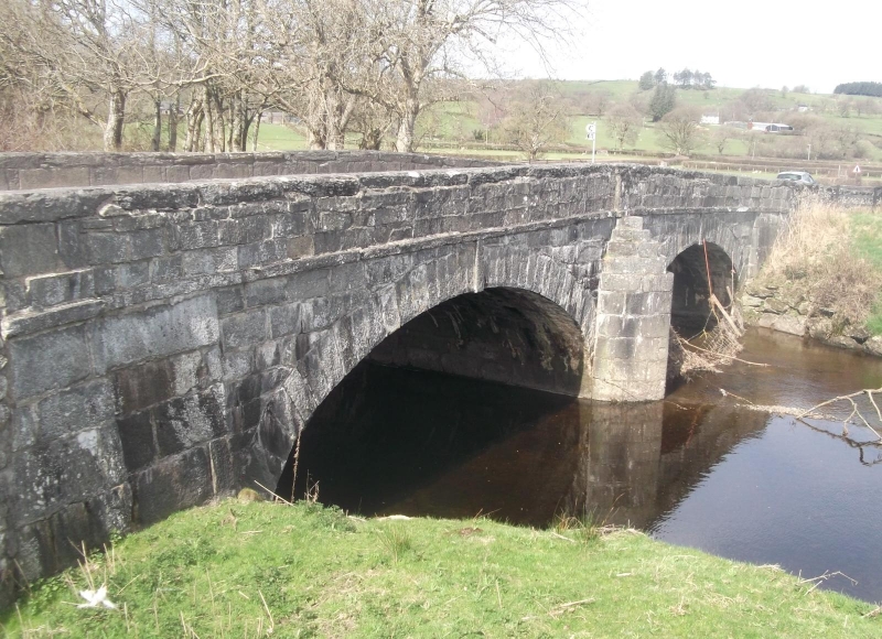
Late C18 or early C19 2-span road bridge with floodarch.
Two-span road bridge with associated revetments adjoining to the L and R, that to the R with further, smaller arch acting as a flood arch. The bridge proper is of coursed and dressed slatestone and has 2 elegant depressed arches with slatestone ashlar voussoirs and projecting keys. Triangular cutwaters to both up- and down-river sides, with diminishing courses to the top, and terminating in flat pilaster sections to the parapet. Further flat pilasters to the L and R ends. The parapet rises slightly to the centre following the gentle hump of the carriageway. It has rough-dressed coping stones and a stringcourse.
The flanking revetted sections are of rubble. That to the R contains the flood arch. This is a segmental arch with rough-dressed voussoirs; sandstone parapet copings to the upriver side, with rough-dressed slatestone to the remainder. The L side (beyond the main, bridge section) has similar sloped rubble revetments with slatestone copings. At the upriver L side is a pedestrian opening, with 5 descending steps leading to a footpath.
Listed as a fine late C18 or early C19 2-span road bridge with floodarch and flaking revettments.
External links are from the relevant listing authority and, where applicable, Wikidata. Wikidata IDs may be related buildings as well as this specific building. If you want to add or update a link, you will need to do so by editing the Wikidata entry.


Other nearby listed buildings
