Approximate Location Map
Large Map »
Latitude: 51.9957 / 51°59'44"N
Longitude: -3.232 / 3°13'55"W
OS Eastings: 315506
OS Northings: 233746
OS Grid: SO155337
Mapcode National: GBR YW.JJXS
Mapcode Global: VH6BV.X3QF
Plus Code: 9C3RXQW9+75
Entry Name: Town Hall
Listing Date: 24 September 1985
Last Amended: 14 August 1995
Grade: II
Source: Cadw
Source ID: 7480
Building Class: Civil
ID on this website: 300007480
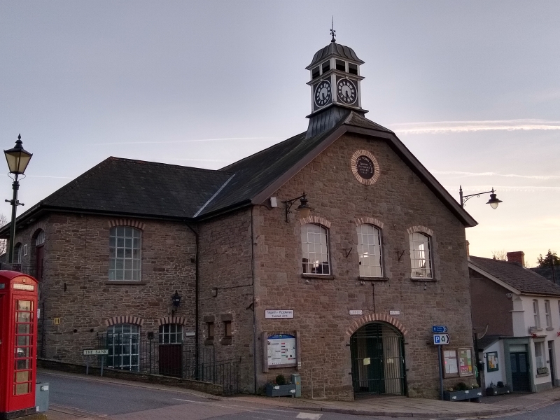
Location: Located on a prominent site in the centre of Talgarth.
County: Powys
Community: Talgarth
Community: Talgarth
Built-Up Area: Talgarth
Traditional County: Brecknockshire
Tagged with: City hall Seat of local government
Built 1877-8 as an Assembly Room with a produce market under, by T Lawrence Lewis, architect. Clock tower added 1887 for Queen Victoria's jubilee, and wing at right angles on the E side, modernised and altered 1994.
Rubble stone with slate roof. Ground floor now has an opening to the square, functioning as a bus shelter, with public conveniences within. Two-storey rubble gable end has, above the shelter, three windows with fixed metal 20-pane glazing, the centre pivot hung, with dressed quoins, the window opening with alternating black and yellow brick voussoirs. Plain bargeboards. Roof quarter hipped. Set behind a quarter hipped roof, a square clock turret with an open stage and ogee lead-clad roof finishing with a finial. The side elevation is of 2 storeys, 5 window bays of similar windows. On the E side, an external stair from The Bank provides access to the 1994 upper floor wing, the C18 railings from Tregunter House now replaced. This wing has a glazed link to a C20 rendered rear service block, also with a slated roof.
Hall is of 5 bays, divided by hammer-beam trusses carried on stone corbels, with tension bars. Single tier of purlins. Stage in S end bay. Square opening in gable end blocked when belltower added.
Listed as the most important visual element on The Square, and of group value with Tower House shop and Talgarth Bridge.
External links are from the relevant listing authority and, where applicable, Wikidata. Wikidata IDs may be related buildings as well as this specific building. If you want to add or update a link, you will need to do so by editing the Wikidata entry.


Other nearby listed buildings
