Approximate Location Map
Large Map »
Latitude: 51.804 / 51°48'14"N
Longitude: -4.9689 / 4°58'8"W
OS Eastings: 195404
OS Northings: 215876
OS Grid: SM954158
Mapcode National: GBR CL.XD57
Mapcode Global: VH1RD.TXHF
Plus Code: 9C3QR23J+JC
Entry Name: The Old Bridge
Listing Date: 12 October 1951
Last Amended: 30 November 2005
Grade: II*
Source: Cadw
Source ID: 12021
Building Class: Transport
ID on this website: 300012021
Location: Situated across river between N end of Bridge Street and Old Bridge.
County: Pembrokeshire
Town: Haverfordwest
Community: Haverfordwest (Hwlffordd)
Community: Haverfordwest
Built-Up Area: Haverfordwest
Traditional County: Pembrokeshire
Tagged with: Road bridge
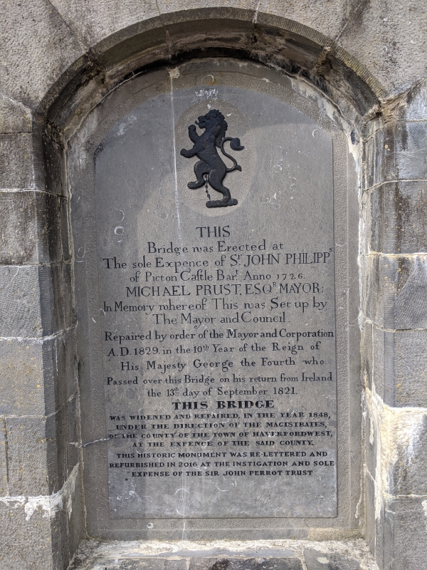
Road bridge over the Western Cleddau first built in 1726 at the expense of Sir John Philipps Bt of Picton Castle, shown in Buck print of c1743. Repaired in 1829, widened on the S side in 1848. The letter book of Erasmus Philipps reveals that the previous bridge had been destroyed by flood, and that the work was to be overseen by Sir John's steward and executed by masons of Haverfordwest. The 1848 widening was under the supervision of William Rowlands, Joseph Jenkins was the contractor, and the cost was to be £450. There is mention of a bridge in 1378, when a grant was made to the chaplain of Holy Trinity chapel on the bridge. In C20 restoration after the traffic was removed a cantilevered pedestrian walkway on the S side was removed.
Road bridge, now pedestrian, four low segmental arches with cutwaters and parapet. Original 1726 upstream side has rough stone arches with stone voussoirs well recessed and rubble stone above. Three big cutwaters of squared stone with pyramidal tops up to parapet coping. On centre cutwater is a plinth with panelled sides, thin cornice and curved top with ball finial, the front panel with inscription 'This bridge was erected at the sole expense of Sir John Philipps of Picton Castle Bart Anno 1726 Michael Prust Esq Mayor in memory whereof this was set up by the mayor and council.' and a second inscription ' Repaired by order of the mayor and corporation AD 1829 in the tenth year of the reign of his majesty George the fourth who passed over the bridge on his return from Ireland the 13th day of September 1821', and a third 'This bridge was widened and repaired in the year 1848 under the direction of the Magistrates of the County of the town of Haverfordwest at the expense of the said County'. The downstream side, of 1848 has grey limestone segmental arches with cut stone voussoirs springing from the cutwaters, which have pyramidal tops and short piers above up to raised band. Band steps down over right arch. Tooled grey stone copings. The bridge is said to be 38 yards (34.75 metres) long and 23 feet (7 metres) wide.
Included at Grade II* for its exceptional architectural interest as a good earlier C18 road bridge widened in matching style in 1848.
External links are from the relevant listing authority and, where applicable, Wikidata. Wikidata IDs may be related buildings as well as this specific building. If you want to add or update a link, you will need to do so by editing the Wikidata entry.


Other nearby listed buildings
