Approximate Location Map
Large Map »
Latitude: 52.0154 / 52°0'55"N
Longitude: -4.8314 / 4°49'53"W
OS Eastings: 205798
OS Northings: 239002
OS Grid: SN057390
Mapcode National: GBR CR.H48R
Mapcode Global: VH2MZ.6LPW
Plus Code: 9C4Q2589+5C
Entry Name: The Church Chapel
Listing Date: 14 April 1992
Last Amended: 14 April 1992
Grade: II
Source: Cadw
Source ID: 12509
Building Class: Religious, Ritual and Funerary
ID on this website: 300012509
Location: Situated at south end of street, facing down Goat Street.
County: Pembrokeshire
Community: Newport (Trefdraeth)
Community: Newport
Built-Up Area: Newport
Traditional County: Pembrokeshire
Tagged with: Church building
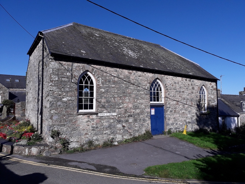
1799 former chapel associated with parish church, now church hall.
Chapel was founded following numerous visits to Newport by John Wesley, 1772-88, and Methodism was encouraged by the rector, D Pugh, illustrating the early close links between the established church and the Methodist cause. In 1811 however the Calvinistic Methodists separated to found the Long Street chapel.
Rubble stone with half-hipped slate roof and east side 3-window facade. Small-paned windows with pointed heads, intersecting glazing bars and stone voussoirs, outer windows are sashes with slate sills and 3 panes wide, whereas the centre window is 4 panes wide and comprises the upper sash only, as fixed light over double doors. It is not clear whether this was originally a double-hung sash as the side windows or a shorter fixed light to allow for the pulpit. The original doors were between the window bays, and are blocked, with stone voussoirs to flat heads.
Plain S end wall. Rear W wall has 2 similar pointed windows. Attached at N end is low single storey stone range with stone N stack, door and 4-pane window.
Altered ca1967-70 in conversion to hall. Boarded 3-sided ceiling.
External links are from the relevant listing authority and, where applicable, Wikidata. Wikidata IDs may be related buildings as well as this specific building. If you want to add or update a link, you will need to do so by editing the Wikidata entry.


Other nearby listed buildings
