Approximate Location Map
Large Map »
Latitude: 51.4385 / 51°26'18"N
Longitude: -3.4271 / 3°25'37"W
OS Eastings: 300906
OS Northings: 172024
OS Grid: ST009720
Mapcode National: GBR HL.NQP0
Mapcode Global: VH6FG.K33K
Plus Code: 9C3RCHQF+C5
Entry Name: Old Beaupre Castle
Listing Date: 22 February 1963
Last Amended: 22 September 1995
Grade: I
Source: Cadw
Source ID: 13171
Building Class: Domestic
Also known as: Beaupre Castle (Wales) -- Photographs
ID on this website: 300013171
Location: Located approximately 2km SW of St Hilary on the E bank of the river Thaw, set on a platformed site, with pedestrian access from St Hilary to St Mary Church road to NW, opposite Howe Mill Farm.
County: Vale of Glamorgan
Community: Llanfair (Llan-fair)
Community: Llanfair
Locality: Old Beaupre
Traditional County: Glamorgan
Tagged with: House Castle Fortified manor house
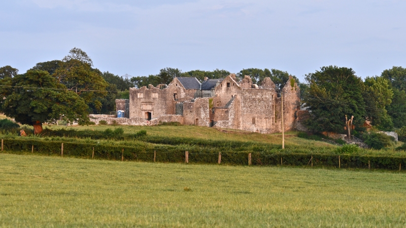
Substantial fortified manor house dating from the C14 to the early C17, now primarily a roofless ruin in State guardianship. The Bassett family occupied the site from the first recorded references in 1262. During the occupancy of Sir Rice Mansel during the C16 the house was extended and developed; the outer gatehouse, the enclosure of the middle court and the later storeyed porch to the central range were erected in 1586 and 1600 respectively. In the C17 the Bassett family abandoned Beaupre in favour of the smaller nearby Fishweir. However, there is evidence of partial habitation during the early C18 with blocked fireplaces and windows in attempts at tax avoidance. The manor was sold in 1709. The building became progressively ruinous with only the SE block continuing to be inhabited as a farmhouse to the present day (separately listed). The history of the house is fully documented in the RCAHMW Inventory.
Constructed of coursed lias limestone rubble with dressings variously of Sutton stone and Bathstone. Roofless and largely floorless. Primarily of three phases of construction . Approached from the NW via an outer court enclosed by low rubble walls; the formerly crenellated gatehouse and curtain wall now ruinous enclose the Middle Court dating from c1586. The gatehouse is of two and a half storeys with dressed four-centred stone doorway and with flanking fluted Ionic pilasters with Bassett coat of arms above flanked by balusters with the initials "R.B,C.B/1586/RB" and the motto: "Gwell angay na chwilydd" (Better death than dishonour). Above are two three-light, square-headed mullioned windows with fragments of a centrally placed, smaller, three-light window above. The S side of the Middle Court is unfenestrated and links the gatehouse to the main hall range to the S and E. On the W side of the Middle Court is a three storey range dating from c1540, having three stacked, four-light mullioned windows, centrally placed on the courtyard elevation. On the S side of these windows is a former grand stairwell which gave access to the Great Chamber on the S and a further large chamber to the N. The S wing is a tall two storey range entered by a magnificent full-height, three-storeyed, late Renaissance porch inscribed with the date 1600, comparable to the frontispiece of other Elizabethan/Jacobean Prodigy Houses eg Kirby Hall, Northants. Flanked by a pair of fluted pilasters standing on plinths of diminishing scale with corresponding Doric capitals to ground, Ionic capitals to first and Corinthian to second floor. At first floor level the Bassett coat of arms with family motto and inscription to Richard Bassett commemorating the construction of the porch in 1600 is surmounted by scrolled and pierced strapwork, set between the pilasters. The ground floor has a four-centred doorway with arabesques to the spandrels, the columns to either side sit on plinths formerly with raised lozenges to the faces. The entablature has alternating paterae and bucrania set within the metopes. The second floor has an eight-light mullion and transom window with strapwork pediment above with engaged pilasters enriched with strapwork and modillion cornice with finial above. Side-lights at first and second floor levels. The S range is four bays wide, floorless and roofless, except for a modern floor at E end. Lit on the N side by two 3-light, square-headed mullioned windows at E end, placed above each other. Lit on the S elevation of the projecting wing at the E end by a three-light, square-headed window with doorway to the E connecting the high level walkway and this wing. Above a corbel table is a two-light window in the gable. The S elevation of the W range is four storeys high and roofless, with six pairs of two-light windows above a narrow four-centred doorway at the N end and in the centre three sets of four-light windows with a wide four-centred doorway at ground floor level. and two, square-headed stairlights at the far N end. The S elevation of the S range is three storeys and roofless and has some surviving mullioned windows at the E end while those at the N end have been lost and the openings left empty.
Largely ruinous with some fireplaces and staircases surviving, particularly in the outer gatehouse and the SE wing. Of particular note is the use of complexly moulded door surrounds with hourglass and thistle stops which are unusual within the Vale. A small fragment of decorative plasterwork survives within the roofed section of the SE range depicting a large Tudor rose and lion rampant. The substantial Great Hall fireplace remains in the S range with armorial shields carved upon the lintol. Full details of the interior and exterior are documented within the RCAHMW Inventory.
Listed grade I as an exceptionally fine C16 manor house.
Scheduled Ancient Monument No. GM1 (part).
External links are from the relevant listing authority and, where applicable, Wikidata. Wikidata IDs may be related buildings as well as this specific building. If you want to add or update a link, you will need to do so by editing the Wikidata entry.


Other nearby listed buildings
