History in Structure

Remains of Dinas Powis Castle

A Grade II Listed Building in Dinas Powis, Vale of Glamorgan

More Photos »
Approximate Location Map
Large Map »

Coordinates

Latitude: 51.4371 / 51°26'13"N

Longitude: -3.2199 / 3°13'11"W

OS Eastings: 315299

OS Northings: 171601

OS Grid: ST152716

Mapcode National: GBR HW.NNST

Mapcode Global: VH6FL.44LP

Plus Code: 9C3RCQPJ+R2

Entry Name: Remains of Dinas Powis Castle

Listing Date: 28 January 1963

Last Amended: 3 May 2002

Grade: II

Source: Cadw

Source ID: 13624

Building Class: Defence

Also known as: Dinas Powis Castle

ID on this website: 300013624

Location: On a wooded spur in Castle Wood, immediately above the C20 development of Lettons Way and reached by footpath from there.

County: Vale of Glamorgan

Town: Cardiff

Community: Dinas Powys

Community: Dinas Powys

Locality: Dinas Powis

Built-Up Area: Dinas Powis

Traditional County: Glamorgan

Tagged with: Castle Architectural structure

Find accommodation in
Dinas Powis

History

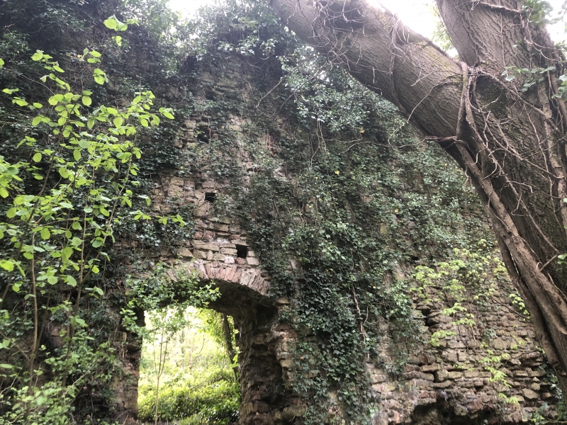
Masonry castle which replaced the ring work on the hill top to the NW and was the fortified headquarters of the Somery family in the C12. The castle continued in use throughout the C13 and there is evidence of some alterations and additions.

Exterior

The remains of the castle stand at the NW end of a long narrow ridge which runs NW-SE. The ridge is steep sided on all sides except the SE and is covered in trees and scrub. The remains consist of an enclosure 65m x 53m surrounded by curtain walling, and the stump of a tower.
The curtain wall encloses a roughly rectangular area on top of the ridge. The interior is cleared and is 1.5m thick, is roughly coursed. Only in the SE corner are any of the window and door dressings left.

Reasons for Listing

Listed as an ancient castle site with substantial medieval masonry.

External Links

External links are from the relevant listing authority and, where applicable, Wikidata. Wikidata IDs may be related buildings as well as this specific building. If you want to add or update a link, you will need to do so by editing the Wikidata entry.

Recommended Books

Other nearby listed buildings

  • II Church of St Peter
    On low-lying ground by the Cadoxton River a short distance N of the village centre.
  • II War Memorial
    In the middle of the triangular green at the centre of the village on paving enclosed by chain fencing hung from stone piers.
  • II Dinas Powys Parish Hall
    Just to W and on rising ground above the village centre, on a railed and walled terrace of random stone reached by steps.
  • II Old Court
    Fronting the W side of the triangular green in the village centre, and at the end of the row attached to The Star Inn.
  • II Lon Twyn
    On rising ground NW of the village centre, set within terraced gardens with views S over the Bristol Channel.
  • II The Mount
    Facing the Common on ground rising from and SW of the village centre. Set back from the road in a walled garden with entrance comprising tall rendered piers and tall decorative wrought iron gates.
  • II Garn-hill and attached garden terrace
    On a south facing slope NE of the hamlet of St Andrews Major, reached by a long drive from the hamlet and set in terraced gardens.
  • II 1-6, Little Orchard
    Little Orchard is a small cul-de-sac opening off the original line of Murch Road on the east side of Dinas Powys. The 6 houses are sited above the access road on its east and south sides.

BritishListedBuildings.co.uk is an independent online resource and is not associated with any government department. All government data published here is used under licence. Please do not contact BritishListedBuildings.co.uk for any queries related to any individual listed building, planning permission related to listed buildings or the listing process itself.

British Listed Buildings is a Good Stuff website.