History in Structure

Aberbechan Aqueduct

A Grade II Listed Building in Llandyssil, Powys

More Photos »
Approximate Location Map
Large Map »

Coordinates

Latitude: 52.5327 / 52°31'57"N

Longitude: -3.2658 / 3°15'56"W

OS Eastings: 314235

OS Northings: 293510

OS Grid: SO142935

Mapcode National: GBR 9V.FGMH

Mapcode Global: VH684.BLWT

Plus Code: 9C4RGPMM+3M

Entry Name: Aberbechan Aqueduct

Listing Date: 14 July 1997

Last Amended: 14 July 1997

Grade: II

Source: Cadw

Source ID: 18540

Building Class: Water Supply and Drainage

ID on this website: 300018540

Location: Carries the Montgomeryshire Canal over the Bechan Brook on the boundary of Llandyssil and Newtown Communities.

County: Powys

Community: Llandyssil (Llandysul)

Community: Llandyssil

Locality: Aberbechan

Traditional County: Montgomeryshire

Tagged with: Aqueduct

Find accommodation in
Newtown

History

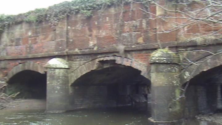
The western branch of the Montgomeryshire Canal from Garthmyl to Newtown was built between 1815 and 1819-21 (Josiah Jessop, engineer, John Williams, builder). The original aqueduct at Aberbechan was repaired in 1859, collapsed and was rebuilt re-using much of the original facing stone, probably in the same year. There is also evidence of later C19 repair.

Exterior

Three-arched masonry aqueduct. Planned on a concave curve over the Bechan Brook, and comprising 3 segmental arches. Finely dressed stone, with hoodmoulds and a string course over the arches. Main central arch flanked by keeled cutwaters, from which spring pilasters articulating the high stone-faced wall of the trough above the arches. This wall terminates in a plain cornice, with simple cast-iron railings on the tow-path side.

Reasons for Listing

Included as a fine example of a small masonry aqueduct, and an important element in the engineering of the Montgomeryshire Canal.

External Links

External links are from the relevant listing authority and, where applicable, Wikidata. Wikidata IDs may be related buildings as well as this specific building. If you want to add or update a link, you will need to do so by editing the Wikidata entry.

Recommended Books

Other nearby listed buildings

  • II Cilgwrgan Bridge
    Bridge spanning the River Severn on the B4389 which links the A483 with Tregynon. Located on the boundary with Newtown and Llanllwchaiarn.
  • II Cilgwrgan
    Located in a low-lying position in the Severn valley fronting the A483.
  • II Aberbechan Bridge
    Spanning the Bechan Brook on the community boundary below the junction of the B4568 with the B4389.
  • II Aberbechan Bridge (partly in Newtown & Llanllwchaiarn community)
    Bridge spanning the Bechan Brook just south of the junction of the B4568 and the B4389. Located on the boundary between the communities of Llandyssil and Newtown & Llanllwchaiarn.
  • II Penarth Feeder Weir
    Adjacent to the sewage works at Dolfor Lock, at the end of the minor road from Llanllwchaiarn. Reached by a footpath from Freestone Lock on the west bank of the River Severn.
  • II Bridge 150 over the Montgomeryshire Canal
    Located approximately 200m SW of Bridge 149 and its adjoining lock. The bridge carries a farm track linking two fields.
  • II* Penarth House
    Set back from the road in its own grounds 3/4 mile South West of the junction of Pool Road with the B4389.
  • II Tynybitfel
    Opposite the junction with Lower Gwestydd Lane and set back from the road on rising ground.

BritishListedBuildings.co.uk is an independent online resource and is not associated with any government department. All government data published here is used under licence. Please do not contact BritishListedBuildings.co.uk for any queries related to any individual listed building, planning permission related to listed buildings or the listing process itself.

British Listed Buildings is a Good Stuff website.