History in Structure

Y golchdy (also known as Yr hen ladd-dy)

A Grade II Listed Building in Pentrefoelas, Conwy

More Photos »
Approximate Location Map
Large Map »

Coordinates

Latitude: 53.0495 / 53°2'58"N

Longitude: -3.6833 / 3°40'59"W

OS Eastings: 287261

OS Northings: 351578

OS Grid: SH872515

Mapcode National: GBR 68.CZQP

Mapcode Global: WH66C.DM90

Plus Code: 9C5R28X8+RM

Entry Name: Y golchdy (also known as Yr hen ladd-dy)

Listing Date: 19 October 1998

Last Amended: 19 October 1998

Grade: II

Source: Cadw

Source ID: 20591

Building Class: Commercial

Also known as: Yr hen ladd-dy

ID on this website: 300020591

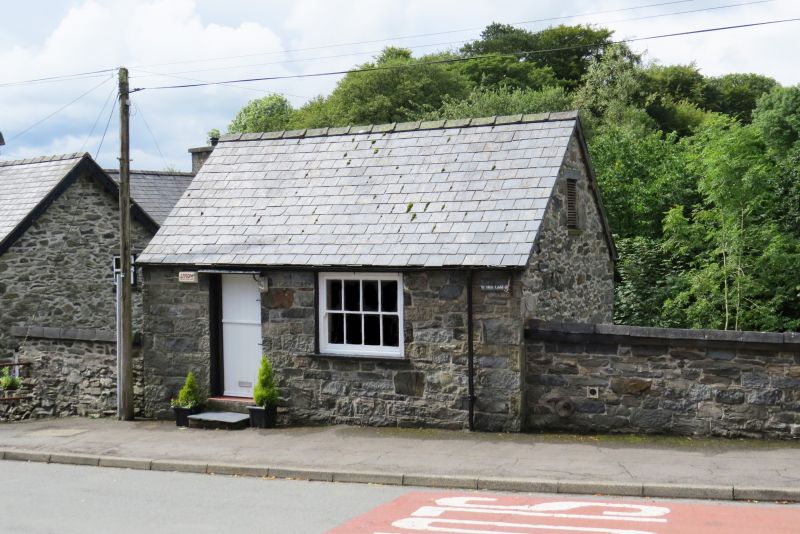
Location: The building stands at the top of the hill rising from the junction with the Holyhead Road, backing on to the small brook.

County: Conwy

Town: Pentrefoelas

Community: Pentrefoelas

Community: Pentrefoelas

Traditional County: Denbighshire

Tagged with: Slaughterhouse

Find accommodation in
Pentrefoelas

History

The building was erected on the site of a C16 corn mill and kilnhouse by the Voelas Estate as a slaughterhouse serving the village.

Exterior

Built of rubble stonework with a slate roof. Single storey, single cell building aligned against the road, with a single stable door and small bracketed board canopy over. One wide 8-paned horned sash window to the front.

Interior

The interior is divided into 2 bays by a central roof truss, ceiled at collar level. Suspended from the purlins is a continuous iron rail for the suspension of carcases.

Reasons for Listing

Included as a scarce surviving example of this building type representing an interesting provision for the community provided by the Voelas estate, and of group value within the village street.

External Links

External links are from the relevant listing authority and, where applicable, Wikidata. Wikidata IDs may be related buildings as well as this specific building. If you want to add or update a link, you will need to do so by editing the Wikidata entry.

Recommended Books

Other nearby listed buildings

  • II Pont-yr-odyn
    The bridge occurs in Pentrefoelas village at the bend at the top of the main street, rising from its junction with the A5 Holyhead Road.
  • II Parish Church
    The church stands on the E side of the road at the top of the rise from its junction with the A5 Holyhead Road.
  • II Bronallt
    The row of estate cottages form a block fronting the Nebo Road on the E side climbing towards the church, and continuing the line established by Nos 1 and 2.
  • II Yr Hen Ysgol
    The building lies alongside the road immediately W of the bridge at the sharp bend.
  • II Foelas Arms Hotel
    The hotel stands in the NW quadrant of the crossroads at the centre of Foelas, and extending at the side along the B5113 Nebo Road.
  • II Dolywen
    The row of estate cottages form a block fronting the Nebo Road on the E side climbing towards the church, and continuing the line established by Nos 1 and 2.
  • II Mill House
    The row of estate cottages form a block fronting the Nebo Road on the E side climbing towards the church, and continuing the line established by Nos 1 and 2.
  • II Bank House
    The two cottages are at the lower end of Nebo Road, by the junction with the Holyhead Road.

BritishListedBuildings.co.uk is an independent online resource and is not associated with any government department. All government data published here is used under licence. Please do not contact BritishListedBuildings.co.uk for any queries related to any individual listed building, planning permission related to listed buildings or the listing process itself.

British Listed Buildings is a Good Stuff website.