Approximate Location Map
Large Map »
Latitude: 51.8712 / 51°52'16"N
Longitude: -3.2632 / 3°15'47"W
OS Eastings: 313129
OS Northings: 219940
OS Grid: SO131199
Mapcode National: GBR YV.S974
Mapcode Global: VH6CF.D77B
Plus Code: 9C3RVPCP+FP
Entry Name: Dan-y-graig Bridge (Canal Bridge No.137)
Listing Date: 17 December 1998
Last Amended: 17 December 1998
Grade: II
Source: Cadw
Source ID: 21110
Building Class: Transport
ID on this website: 300021110
Location: S of the B4558, E of Llangynidr and SE of the hamlet of Llanddetti.
County: Powys
Community: Talybont-on-Usk (Tal-y-bont ar Wysg)
Community: Talybont-on-Usk
Locality: Llanddetti
Traditional County: Brecknockshire
Tagged with: Bridge Road bridge
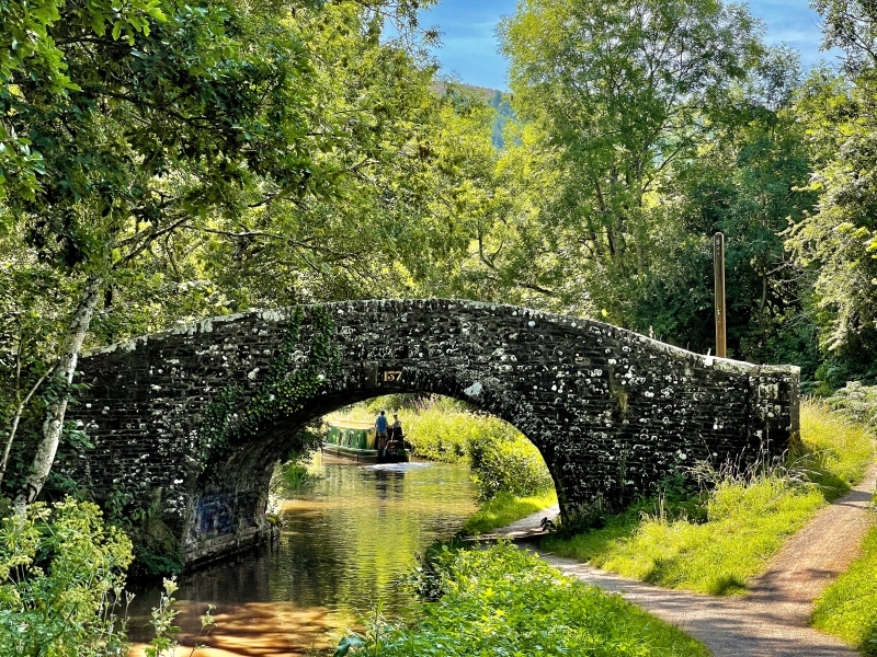
The Brecknock and Abergavenny Canal was promoted in 1792 to connect the upper Usk valley with the Monmouthshire Canal at Pontymoile and from there to the sea at Newport. First section, between Gilwern and Talybont, was cut between 1797 and 1799, with upper section between Talybont and Brecon opened in 1800, both sections engineered by Thomas Dadford. Lower section between Gilwern and Pontymoile completed 1812 and engineered by William Crosley. Linked to tramroads, the canal was an important artery for trade in iron, lime and coal. In 1865 the Brecknock and Abergavenny and the Monmouthshire Canals merged to become the Monmouthshire and Brecon Canal, which was later incorporated into the Great Western Railway. Many bridges had large cast iron weight restriction notices on poles erected at each end. Last toll was taken in 1933. Restoration of canal began 1964.
Hump-backed bridge of rubble sandstone. Segmental arch has keystones, thin voussoirs and low parapet with flat coping. The abutments curve outwards on both sides and parapet has square end piers. The towpath passes under bridge on N side where there is a stone kerb; on S side is a string course near water level.
This bridge provided access to a field barn. Grass track surface. Number plate lost. Cast iron posts for weight restriction notice, signs lost.
One of a group of original Brecknock and Abergavenny Canal bridges.
External links are from the relevant listing authority and, where applicable, Wikidata. Wikidata IDs may be related buildings as well as this specific building. If you want to add or update a link, you will need to do so by editing the Wikidata entry.


Other nearby listed buildings
