History in Structure

Pont y pandy

A Grade II Listed Building in Dolbenmaen, Gwynedd

More Photos »
Approximate Location Map
Large Map »

Coordinates

Latitude: 52.9683 / 52°58'5"N

Longitude: -4.1613 / 4°9'40"W

OS Eastings: 254952

OS Northings: 343396

OS Grid: SH549433

Mapcode National: GBR 5N.K3MY

Mapcode Global: WH55D.1NQB

Plus Code: 9C4QXR9Q+8F

Entry Name: Pont y pandy

Listing Date: 30 March 1999

Last Amended: 30 March 1999

Grade: II

Source: Cadw

Source ID: 21540

Building Class: Transport

ID on this website: 300021540

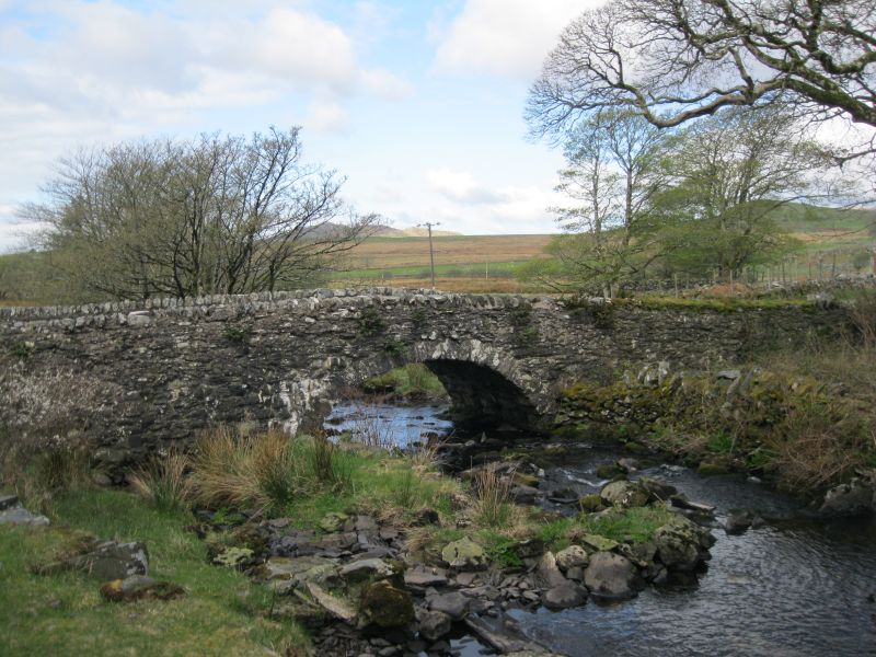
Location: Located below Ynys Pandy mill, carrying the road to Cwmystradllyn over the Afon Henwy.

County: Gwynedd

Town: Dolbenmaen

Community: Dolbenmaen

Community: Dolbenmaen

Locality: Cwmystradllyn

Traditional County: Caernarfonshire

Tagged with: Bridge

Find accommodation in
Tremadoc

History

A simple country bridge built in the late C18 or early C19 perhaps in connection with the early development of slate extraction at Gorseddau. On the NE side, the ruins of the weigh-house serving Ynys Pandy felin llechi.

Exterior

Built of local rubble slate stone. A segmental arch rising 2.1m and spanning 5.4m composed of stone voussoirs with flush spandrels and parapets, coped with stone-on-edge copings. The carriageway over is 3.1m wide between the 45cm parapets.

Reasons for Listing

Included as a modest country bridge of group value with Ynys Pandy mill.

External Links

External links are from the relevant listing authority and, where applicable, Wikidata. Wikidata IDs may be related buildings as well as this specific building. If you want to add or update a link, you will need to do so by editing the Wikidata entry.

Recommended Books

Other nearby listed buildings

  • II* Ynys Pandy felin lechi
    The mill stands on a bluff overlooking the S bank of the Afon Henwy, in the Cwmystradllyn.
  • II Farm Building at Ereiniog
    The farm building is on sloping ground SW of the farm house and with its gable against the road leading from Ystradllyn to Cwm Pennant.
  • II Ereiniog
    The farmhouse stands on a hilltop, E of Ynyspandy mill and is reached by a farm road from Cwmystradllyn.
  • II Ty-newydd, with attached walls
    The house stands alone on the verge of a minor road from Prenteg to Cwm Pennant, in a re-entrant angle of the field wall.
  • II Cowhouse at Isallt-fawr
    Issalt-fawr lies at the lower S end of Cwm Pennant, at the foot of the slope of Moel Issalt. The cowhouse stands some distance away to the SE of the farmhouse
  • II Outfield yard group at Clenennau
    The farm group lies apart and to the NE of the main house and farmyard.
  • II Carthouse, Stable and Granary at Isallt-fawr
    Issalt-fawr lies at the wider S end of Cwm Pennant, on the lower slope of Moel Issalt. The carthouse building stands in front and at right angles to the main S front of the farmhouse.
  • II Isallt-fawr
    The farm is set on sloping ground on the E side of the wider, lower section of Cwm Pennant, and is reached from a straight road leading E, N of Brynkir.

BritishListedBuildings.co.uk is an independent online resource and is not associated with any government department. All government data published here is used under licence. Please do not contact BritishListedBuildings.co.uk for any queries related to any individual listed building, planning permission related to listed buildings or the listing process itself.

British Listed Buildings is a Good Stuff website.