History in Structure

Llandybie Bridge

A Grade II Listed Building in Llandybie, Carmarthenshire

More Photos »
Approximate Location Map
Large Map »

Coordinates

Latitude: 51.8208 / 51°49'14"N

Longitude: -4.0048 / 4°0'17"W

OS Eastings: 261917

OS Northings: 215474

OS Grid: SN619154

Mapcode National: GBR DV.WK86

Mapcode Global: VH4J9.JHNJ

Plus Code: 9C3QRXCW+83

Entry Name: Llandybie Bridge

Listing Date: 27 August 1999

Last Amended: 27 August 1999

Grade: II

Source: Cadw

Source ID: 22209

Building Class: Transport

ID on this website: 300022209

Location: At the crossing of Church St / King's Road over the Afon Marlais in Llandybie village.

County: Carmarthenshire

Town: Ammanford

Community: Llandybie (Llandybïe)

Community: Llandybie

Locality: Llandybie village

Built-Up Area: Llandybie

Traditional County: Carmarthenshire

Tagged with: Bridge Road bridge

Find accommodation in
Llandybie

History

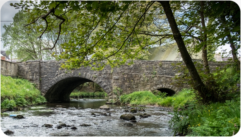
A bridge probably of the mid- or late-C19.

Exterior

A stone bridge with slightly skewed high segmental main span of about 6m. To the east side of the main channel is a small span of about 1.5m wide, similarly constructed, which may be connected functionally with the nearby listed corn mill as a tail-race arch. The bridge is in masonry consisting mostly of axe-squared limestone laid in snecked courses. Much of the masonry including the voussoirs is rock-faced.
Carriageway about 7m wide between parapets about 0.9m high. Flat parapet copings also rock-faced where of limestone; some of the copings are in gritstone. At the south east the parapet has a small return to the river bank.

Reasons for Listing

A C19 bridge of vernacular character in a group with the listed village corn mill and miller's house.

External Links

External links are from the relevant listing authority and, where applicable, Wikidata. Wikidata IDs may be related buildings as well as this specific building. If you want to add or update a link, you will need to do so by editing the Wikidata entry.

Recommended Books

Other nearby listed buildings

  • II The Mill, Llandybie
    Beside Afon Marlais to the north east of Llandybie Bridge. Former miller's house immediately to its east.
  • II Stone Spheres at Entrance to PLâs Llandybie
    At the entrance to the village-centre site of the former Plâs. About 30m west of Llandybie bridge, at south side of street.
  • II The Mill House, Llandybie
    To the east of Llandybie mill. Stone rubble enclosing wall (modern concrete blockwork to street side) with steps down to the mill yard.
  • II* Church of St. Tybie
    At the centre of Llandybie village. Large stone-walled graveyard to north side (recent parts walled in concrete blocks). High wall with steps and iron gates from the street at west and south; stile be
  • II Llandybie National School
    At the west side of High Street, within a large playground. About 100m south of the Parish Church.
  • II The Red Lion Inn
    At the south side of Llandeilo Road, about 50m west of the Parish Church.
  • II Agricultural Range Opposite Red Lion Inn
    Detached immediately opposite the Red Lion Hotel, on the northern edge of Llandybie; farmyard to rear and to left.
  • II American Villas
    At west side of Ammanford Road, between the Afon Marlais and Rawling Road.

BritishListedBuildings.co.uk is an independent online resource and is not associated with any government department. All government data published here is used under licence. Please do not contact BritishListedBuildings.co.uk for any queries related to any individual listed building, planning permission related to listed buildings or the listing process itself.

British Listed Buildings is a Good Stuff website.