Approximate Location Map
Large Map »
Latitude: 51.747 / 51°44'49"N
Longitude: -3.3767 / 3°22'36"W
OS Eastings: 305051
OS Northings: 206264
OS Grid: SO050062
Mapcode National: GBR HN.15CQ
Mapcode Global: VH6CY.FC72
Plus Code: 9C3RPJWF+R8
Entry Name: Former Miner's Welfare Hall
Listing Date: 13 January 1988
Last Amended: 8 April 2004
Grade: II
Source: Cadw
Source ID: 82671
Building Class: Health and Welfare
Also known as: Former Miner's Welfare Hall
ID on this website: 300082671
Location: Prominently sited on the way to Thomastown from High Street.
County: Merthyr Tydfil
Town: Merthyr
Community: Town (Y Dref)
Community: Town
Built-Up Area: Merthyr Tydfil
Traditional County: Glamorgan
Tagged with: Chapel Pub Architectural structure
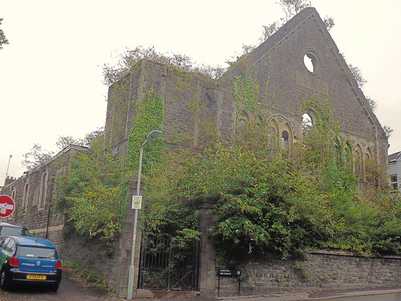
Originally built ca 1855 as Shiloh Welsh Wesleyan Chapel. Probably designed by I K Brunel, engineer to Vale of Neath Railway Company who erected the new chapel when the railway station was built on the earlier site. Corner town cut down and building lengthened in 1921 when converted to Miners’ Hall. Recently (Spring 1987) converted to club use.
Tall, gabled Romanesque front, snecked rubble facings, freestone dressings, modern slate roofs with bargeboards. Gable corbel-table rises from end pilasters with outer scalloped capitals linked horizontally by stringcourse; sill-band. Oculus with chevron splay and hoodmould to gable; incised lettering below. 9-light window band set into Romanesque interlace with taller two-order centre window, chevron to arch-ring, nook-shafts with scallop capitals. Three arched doorways, centre with corbelled hoodmoulds, chevron arch-ring and nook shafts with scallop capitals; plain boarded doors and tympana. Cut-down tower on left with modern hipped roof, recessed panels.
Terraced forecourt with original outer gatepiers and ironwork railings on side walls.
Aisled side elevation to Tramroad Site North with four 3-light interlaced clerestory windows, plainer arched openings below; different treatment to added bay.
Interior retains 3-sided galleries on columns and large blind arch with corbelled hoodmould.
First listed in 1988 corrected record no 08/04/2004
External links are from the relevant listing authority and, where applicable, Wikidata. Wikidata IDs may be related buildings as well as this specific building. If you want to add or update a link, you will need to do so by editing the Wikidata entry.


Other nearby listed buildings
