History in Structure

Lychgate and churchyard walls, Church of St Tecwyn

A Grade II Listed Building in Talsarnau, Gwynedd

More Photos »
Approximate Location Map
Large Map »

Coordinates

Latitude: 52.9183 / 52°55'5"N

Longitude: -4.0357 / 4°2'8"W

OS Eastings: 263227

OS Northings: 337594

OS Grid: SH632375

Mapcode National: GBR 5T.N45G

Mapcode Global: WH55M.ZXD4

Plus Code: 9C4QWX97+8P

Entry Name: Lychgate and churchyard walls, Church of St Tecwyn

Listing Date: 30 December 2004

Last Amended: 30 December 2004

Grade: II

Source: Cadw

Source ID: 83456

Building Class: Religious, Ritual and Funerary

ID on this website: 300083456

Location: At the end of a country lane, once the county road to Maentwrog, c1km W of the main village of Llandecwyn.

County: Gwynedd

Community: Talsarnau

Community: Talsarnau

Locality: Llandecwyn

Traditional County: Merionethshire

Tagged with: Lychgate

Find accommodation in
Llandecwyn

History

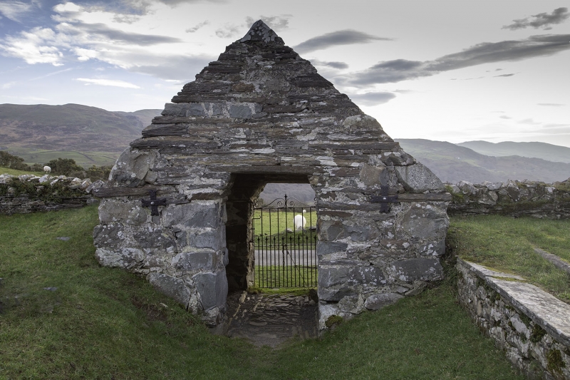
The present Church of St Tecwyn is almost wholly of 1879-80, but replaced an earlier building on the site. The churchyard walls and lychgate predate this rebuilding of the church. The walls are difficult to date, but the lychgate is probably C17 or C18

Exterior

Simple rubble (largely fieldstone) walls with rough copings bounding near circular churchyard, with lychgate towards SW corner. This is built of roughly coursed rubble, using characteristic long blocks. Coped gables and slate roof. Shouldered doorways in each elevation.
There is a monopitched bier house forming part of the churchyard wall with slab parapet abutting the SE corner of the churchyard. It has a wide opening onto the lane S of the site and evidence of a blocked opening into the churchyard.

Reasons for Listing

Listed as a lychgate and churchyard walls, with good vernacular qualities, and part of a group with the Church of Saint Tecwyn and Ty'n Llan.

External Links

External links are from the relevant listing authority and, where applicable, Wikidata. Wikidata IDs may be related buildings as well as this specific building. If you want to add or update a link, you will need to do so by editing the Wikidata entry.

Recommended Books

Other nearby listed buildings

  • II Ty'n Llan
    Located at the SW corner of the churchyard of the Church of St Tecwyn.
  • II Church of St Tecwyn
    At the end of a country lane, once the county road to Maentwrog, c1km W of the main village of Llandecwyn.
  • II Lofted stable and cartshed at Plas Llandecwyn
    Set back from the E side of the country lane, once the country road to Maentwrog, which leads to the Church of St Tecwyn. The range lies to the W of the house.
  • II Plas Llandecwyn
    Set back from the E side of the country lane, once the country road to Maentwrog, which leads to the Church of St Tecwyn.
  • II Agricultural range at Plas Llandecwyn
    Set back from the E side of the country lane, once the country road to Maentwrog, which leads to the Church of St Tecwyn. The barn lies directly S of the house.
  • II Cottage at Plas Llandecwyn
    Set back from the E side of the country lane, once the country road to Maentwrog, which leads to the Church of St Tecwyn. The building lies to the S of the house and barn at Plas Llandecwyn.
  • II Field barn at Plas Llandecwyn
    Along the W side of the country lane, once the country road to Maentwrog, which leads to the Church of St Tecwyn; opposite the entrance to Plas Llandecwyn.
  • II Glanllyn Cottage
    Set back slightly from the S and E sides of the country road which leads N from Eisingrug to the Church of St Tecwyn, at the junction with the road down to the village of Llandecwyn at Bryn Bwbach.

BritishListedBuildings.co.uk is an independent online resource and is not associated with any government department. All government data published here is used under licence. Please do not contact BritishListedBuildings.co.uk for any queries related to any individual listed building, planning permission related to listed buildings or the listing process itself.

British Listed Buildings is a Good Stuff website.