History in Structure

Folly at Tan-y-Bwlch

A Grade II Listed Building in Maentwrog, Gwynedd

More Photos »
Approximate Location Map
Large Map »

Coordinates

Latitude: 52.9467 / 52°56'48"N

Longitude: -3.9938 / 3°59'37"W

OS Eastings: 266127

OS Northings: 340670

OS Grid: SH661406

Mapcode National: GBR 5W.LG8V

Mapcode Global: WH55N.M6CB

Plus Code: 9C4RW2W4+MF

Entry Name: Folly at Tan-y-Bwlch

Listing Date: 25 February 2005

Last Amended: 25 February 2005

Grade: II

Source: Cadw

Source ID: 83997

Building Class: Domestic

ID on this website: 300083997

Location: In an isolated location, set well back from the S side of the A487(T) and on the flood plain of the Afon Dwyryd. Lies to S of the Oakeley Arms.

County: Gwynedd

Community: Maentwrog

Community: Maentwrog

Locality: Tan-y-bwlch

Traditional County: Merionethshire

Tagged with: Folly

Find accommodation in
Maentwrog

History

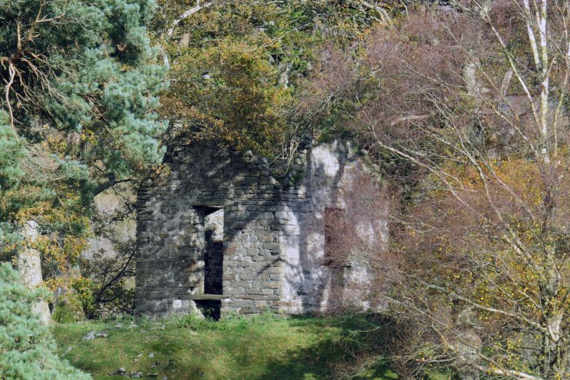
Several views and maps from the late C18 onwards show a small apparently artificial wooded knoll surmounted by a small building (it is first clearly visible on a sketch by J Ingleby, 1794). Nothing else is known about this building, which was presumably a folly or eye-catcher in the view from Plas-tan-y-bwlch. The building probably had a slate roof originally, but has been roofless since before 1888.

Exterior

Single storey folly, built to a square plan and now roofless. The structure is built of coursed and mortared rubble masonry with a gable to each elevation. There is a single window in the S elevation and another window or doorway in the north. The structure was fenced off and partially obscured by vegetation at the time of the survey (July 2003).

Interior

The interior was not inspected at the time of the survey (June/July 2003).

Reasons for Listing

Listed notwithstanding its condition, as a late eighteenth century folly associated with Plas-tan-y-bwlch.

External Links

External links are from the relevant listing authority and, where applicable, Wikidata. Wikidata IDs may be related buildings as well as this specific building. If you want to add or update a link, you will need to do so by editing the Wikidata entry.

Recommended Books

Other nearby listed buildings

  • II Milestone at the Oakeley Arms
    Set at the N side of the A487(T) at its junction with the B4410, to NE end of the small hamlet of Tan-y-bwlch. The milestone is set in a wall at the S corner of the Oakeley Arms.
  • II Former kiln house at Tan-y-bwlch mill
    Set alongside the NW side of the A487(T) in the centre of the small hamlet of Tan-y-bwlch. Directly to NE of the former mill and mill house.
  • II The Oakeley Arms Hotel
    Set at the N side of the A487(T) at its junction with the B4410, to NE end of the small hamlet of Tan-y-bwlch.
  • II Ty'r Felin
    Set alongside the NW side of the A487(T) in the centre of the small hamlet of Tan-y-bwlch.
  • II The White Barn
    In a slightly elevated position, set back from the SE side of the A487(T) in the centre of the small hamlet of Tan-y-bwlch.
  • II Church of St. Twrog
    Set back from the W side of Bull Street (A496) in the centre of the village of Maentwrog. Entry to the church grounds is via the lychgate between Neuadd Llewelyn and Pen-y-Bryn.
  • II Hay Barn adjacent to Yr Hen Ysgubor and Crochendy Twrog
    On S side of A487, about 250m SW of junction with B 4410, aligned with road, attached to E of Yr Hen Ysgubor.
  • II Coach house range at the Oakeley Arms
    Set at the N side of the A487(T) at its junction with the B4410, to NE end of the small hamlet of Tan-y-bwlch. The coach house range is directly N of the Oakeley Arms.

BritishListedBuildings.co.uk is an independent online resource and is not associated with any government department. All government data published here is used under licence. Please do not contact BritishListedBuildings.co.uk for any queries related to any individual listed building, planning permission related to listed buildings or the listing process itself.

British Listed Buildings is a Good Stuff website.