Approximate Location Map
Large Map »
Latitude: 50.8173 / 50°49'2"N
Longitude: -2.1163 / 2°6'58"W
OS Eastings: 391899
OS Northings: 101978
OS Grid: ST918019
Mapcode National: GBR 1ZX.RRL
Mapcode Global: FRA 66GY.1B3
Plus Code: 9C2VRV8M+WF
Entry Name: Crawford Bridge
Listing Date: 14 July 1955
Grade: I
Source: Historic England
Source ID: 1305264
English Heritage Legacy ID: 103347
ID on this website: 101305264
Location: Spetisbury, Dorset, DT11
County: Dorset
Civil Parish: Spetisbury
Built-Up Area: Spetisbury
Traditional County: Dorset
Lieutenancy Area (Ceremonial County): Dorset
Church of England Parish: Spetisbury St John the Baptist
Church of England Diocese: Salisbury
Tagged with: Bridge Road bridge
SPETISBURY
ST 90 SW
14-7-55
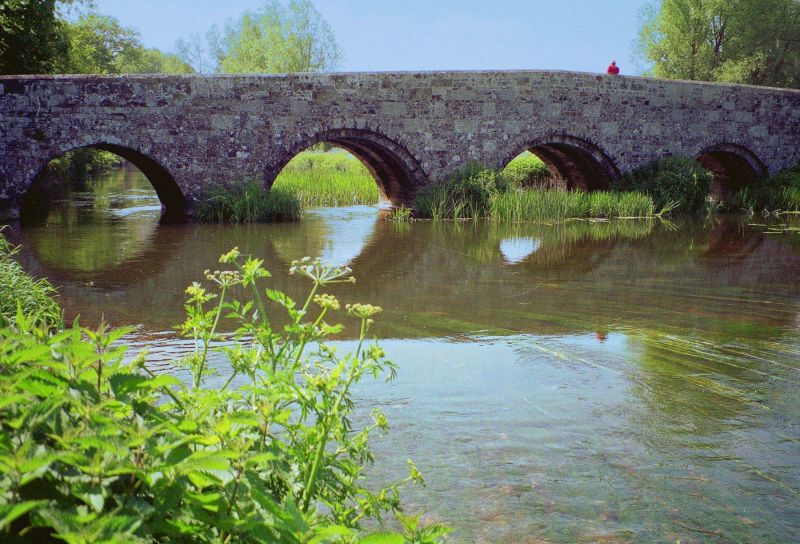
8/71 Crawford Bridge
- I
Road Bridge over river Stour, medieval, widened in 1819. Coursed rubble and ashlar
of 9 semi circular arches. Upstream are triangular cut-waters carried up at alternate
piers to form pedestrian refuges. Parapets of chequered flint and ashlar with pitched
ashlar coping. Reset stone in east side inscribed 1719. (RCHM, Dorset, vol.III, p.243/4, no.2. Newman, J. and Pevsner, N., The Buildings of England: Dorset, 1972, p.395.)
Listing NGR: ST9189901978
External links are from the relevant listing authority and, where applicable, Wikidata. Wikidata IDs may be related buildings as well as this specific building. If you want to add or update a link, you will need to do so by editing the Wikidata entry.


Other nearby listed buildings
