Approximate Location Map
Large Map »
Latitude: 54.5879 / 54°35'16"N
Longitude: -1.8132 / 1°48'47"W
OS Eastings: 412167
OS Northings: 521432
OS Grid: NZ121214
Mapcode National: GBR HHSD.74
Mapcode Global: WHC5D.3YT6
Plus Code: 9C6WH5QP+5P
Entry Name: Footbridge Approximately 20 Metres South-East of Bath House
Listing Date: 30 September 1987
Grade: II
Source: Historic England
Source ID: 1310742
English Heritage Legacy ID: 111465
ID on this website: 101310742
Location: Raby, County Durham, DL2
County: County Durham
Civil Parish: Raby with Keverstone
Traditional County: Durham
Lieutenancy Area (Ceremonial County): County Durham
Church of England Parish: Staindrop
Church of England Diocese: Durham
Tagged with: Footbridge
RABY WITH KEVERSTONE RABY PARK
NZ 1221
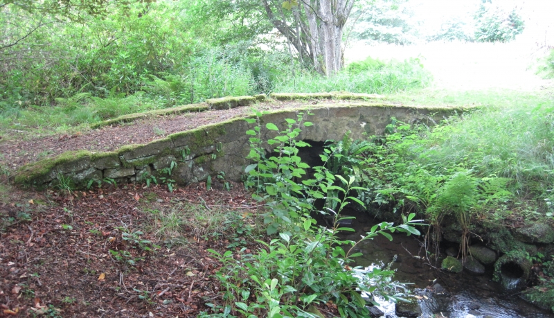
16/100 Footbridge
approximately 20
metres south-east
of Bath House
GV II
Bridge. Third quarter C18. Sandstone. Random rustication to voussoirs of low
segmental arch supporting dwarf flat-topped parapets, slightly higher at centre
of bridge.
Listing NGR: NZ1216721432
External links are from the relevant listing authority and, where applicable, Wikidata. Wikidata IDs may be related buildings as well as this specific building. If you want to add or update a link, you will need to do so by editing the Wikidata entry.


Other nearby listed buildings
