Approximate Location Map
Large Map »
Latitude: 51.8644 / 51°51'51"N
Longitude: 1.2881 / 1°17'17"E
OS Eastings: 626486
OS Northings: 223539
OS Grid: TM264235
Mapcode National: GBR VRQ.2GN
Mapcode Global: VHLCV.8DVL
Plus Code: 9F33V77Q+Q7
Entry Name: Naze Tower
Listing Date: 21 June 1984
Grade: II*
Source: Historic England
Source ID: 1165846
English Heritage Legacy ID: 119945
ID on this website: 101165846
Location: Tendring, Essex, CO14
County: Essex
District: Tendring
Civil Parish: Frinton and Walton
Built-Up Area: Walton-on-the-Naze
Traditional County: Essex
Lieutenancy Area (Ceremonial County): Essex
Church of England Parish: Walton-le-Soken All Saints
Church of England Diocese: Chelmsford
Tagged with: Lighthouse
This list entry was subject to a Minor Amendment on 27 April 2022 to remove superfluous amendment details and to reformat the text to current standards
TM 22 SE
4/96
FRINTON AND WALTON
THE NAZE,
WALTON-ON-THE-NAZE
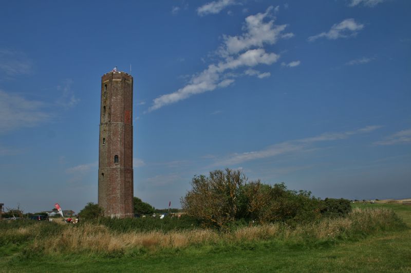
Naze Tower
21.6.84
II*
Navigation Tower. Dated 1720 for Trinity House. Plum coloured brick. Octagonal of three reducing stages with clasping buttresses to angles. C19/C20 upper stage. Moulded brick plinth with 1979 concrete plinth below. Third stage with two upper roundheaded window openings, one now blocked and three windows above second stage, two now blocked. Two round headed windows to second stage and a single window to first stage. C20 double vertically boarded doors, concrete lintel over. A lead plaque over doorway relates "Trinity House 1720".
Internally the tower has several storeys reached by an iron spiral staircase. Iron framework to top section. Designed to serve with Walton Hall Tower q.v. 4/88 as a guide to vessels through the Goldmer Gap and also with a light in Suffolk to lead into the Suffolk/Essex border rivers.
Listing NGR: TM2648623539
External links are from the relevant listing authority and, where applicable, Wikidata. Wikidata IDs may be related buildings as well as this specific building. If you want to add or update a link, you will need to do so by editing the Wikidata entry.


Other nearby listed buildings
