Approximate Location Map
Large Map »
Latitude: 51.9519 / 51°57'6"N
Longitude: -1.9709 / 1°58'15"W
OS Eastings: 402095
OS Northings: 228152
OS Grid: SP020281
Mapcode National: GBR 3N1.LJH
Mapcode Global: VHB1K.S6FJ
Plus Code: 9C3WX22H+PJ
Entry Name: The Old Vicarage
Listing Date: 4 July 1960
Grade: II
Source: Historic England
Source ID: 1340244
English Heritage Legacy ID: 133986
ID on this website: 101340244
Location: Winchcombe, Tewkesbury, Gloucestershire, GL54
County: Gloucestershire
District: Tewkesbury
Civil Parish: Winchcombe
Built-Up Area: Winchcombe
Traditional County: Gloucestershire
Lieutenancy Area (Ceremonial County): Gloucestershire
Church of England Parish: Winchcombe St Peter
Church of England Diocese: Gloucester
Tagged with: Clergy house
SP 02 28 WINCHCOMBE GLOUCESTER STREW
(south side)
4/88
The Old Vicarage
4.7.1960
GV II
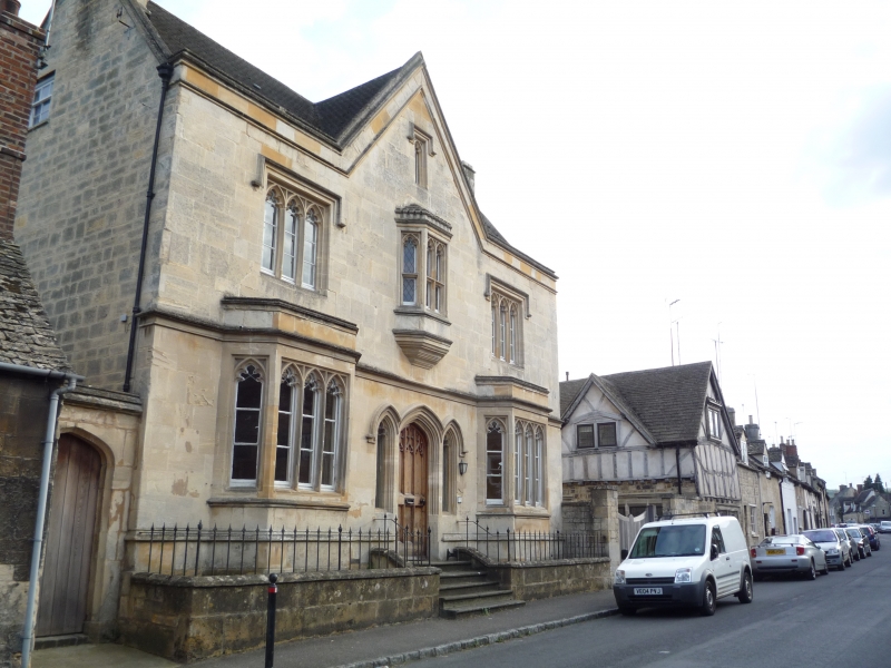
Large detached house set back from street. Mid C19. Gothic style villa.
Limestone ashlar, concrete tile roof, but some stone slab remaining on
mansard roof in back range. A complex parallel range assembly with
symmetrical street frontage but irregular back including large square bay.
Street front two storeys and attic with cellar, 3-windowed: parapeted
hexagonal bays through two storeys to coped gables above, and central oriel
with castellated top, and central coped gable. Stone mullioned and transomed
windows with cusped heads, continuous moulded string over heads of ground
floor windows. Centrally a 4-centred opening to original traceried door
flanked by two single cusped lights, all under continuous triple-arched
drip course, approached by five wide steps with nosings; also plank door
and 4-centred arch in coped wall, left, adjoining No 54 (q.v.). Small
2-light casements to attics, right and left gables, and in back wall two
large C19 multi-pane sashes with bars, a small lancet opening to start, and
square bay with hipped roof and large mullioned and transomed 3 light
window. Front plinth with low boundary wall at pavement back, with saddle
back coping, full width of property, carried to adjoining property, left,
and to pier, right.
Listing NGR: SP0209528152
External links are from the relevant listing authority and, where applicable, Wikidata. Wikidata IDs may be related buildings as well as this specific building. If you want to add or update a link, you will need to do so by editing the Wikidata entry.


Other nearby listed buildings
