Approximate Location Map
Large Map »
Latitude: 53.5292 / 53°31'45"N
Longitude: -2.2864 / 2°17'11"W
OS Eastings: 381111
OS Northings: 403657
OS Grid: SD811036
Mapcode National: GBR DWGM.SL
Mapcode Global: WH983.VKF8
Plus Code: 9C5VGPH7+MC
Entry Name: Barlowe Grave Slab in Churchyard of Church of St Mary
Listing Date: 21 February 2012
Grade: II
Source: Historic England
Source ID: 1406295
ID on this website: 101406295
Location: St Mary's Church, Prestwich, Bury, Greater Manchester, M25
County: Bury
Electoral Ward/Division: St Mary's
Parish: Non Civil Parish
Built-Up Area: Manchester
Traditional County: Lancashire
Lieutenancy Area (Ceremonial County): Greater Manchester
Church of England Parish: Prestwich St Mary
Church of England Diocese: Manchester
Tagged with: Grave slab
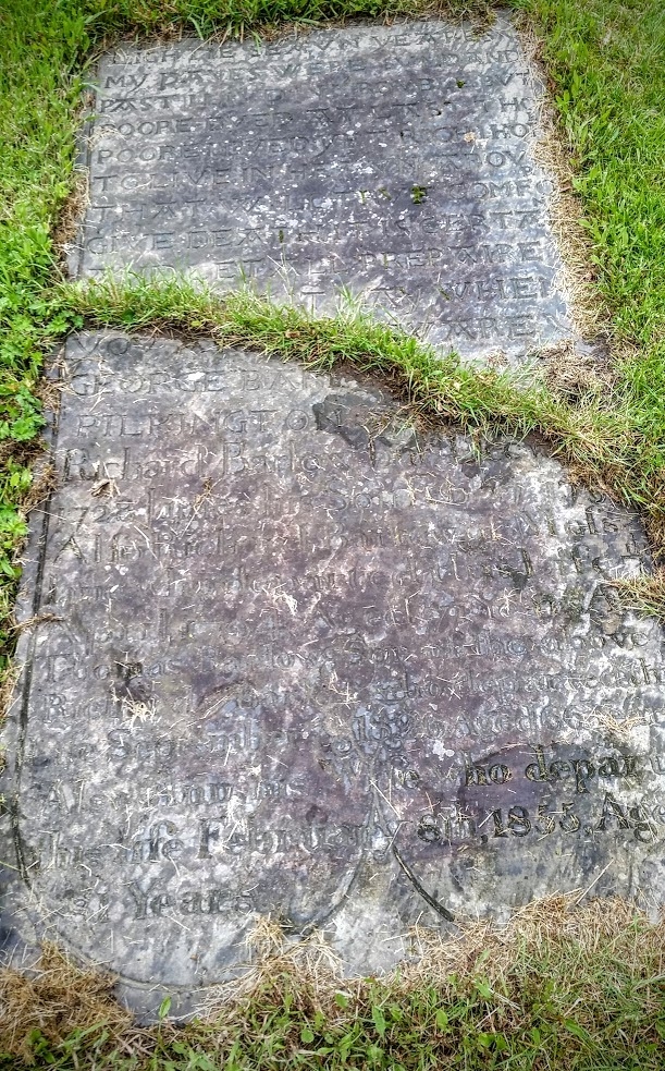
Grave slab commemorating George Barlowe and family, c1686, later C18 and C19 inscriptions.
Sandstone, rectangular slab with central break due to lawn mower damage. Incised carving including border. Incised decorative flower motif to the foot of the slab, now partly obscured by later text. An epitaph to the top of the slab in widely-spaced early Modern English reads 'EIGHTIE SEAVN YEARES/ MY DAYES WERE SVM'D AND/ PAST I LIV'D IN TROVBLE BVT/ POORE DYED AT LAST THO/ POORE I DYED YET RICH I HOPE/ TO LIVE IN HEAV'N ABOVE/ THAT WILL TRVE COMFORT/ GIVE DEATH IT IS CERTAINE/ AND LET ALL PREPAIRE/ FOR COME IT MAY WHEN/ YOV ARE VNAWARE'. An inscription below in same writing reads 'GEORGE BARLOWE OF/ PILKINGTON 1686'. An inscription below in normal-spaced lettering reads 'Richard Barlow burd Dec 10/ 1728 James his Son Feb 27 1731/ Also Richard Barlow of Mofs Lane/ who departed this Life 7th/ April 1794 Aged 71 Years Also/ Thomas Barlow Son of the above/ Richard Barlow who departed this/ Life September 7th 1826 Aged 66 Years/ Also Ann his Wife who departed/ this Life February 8th 1855 Aged/ 81 Years'.
St Mary's Church, Prestwich, dates to the C14 with later alterations, and the oldest extant grave marker in the churchyard dates to 1641. However, the topography of the churchyard suggests a much older burial ground. The churchyard has been extended many times, including in 1827 when boundary walls were constructed. Prior to these walls being erected the churchyard was enclosed by a ditch and hedge created in 1706, and subsequently by the planting of beech and fir trees in 1763. Further extensions of the churchyard occurred in 1864, 1886, 1924 and 1950.
The western section of the churchyard contains, amongst other graves, the unmarked burials of thousands of inmates of the County Asylum Prestwich dating from the mid-C19 to early-C20, although several communal graves for the asylum's attendants and some inmates are marked by grave slabs. In 1801 a hearse house (altered in the mid-late C20) was constructed to the north of the church.
The Barlowe grave slab, c1686, in the St Mary's churchyard, Prestwich, is designated at Grade II for the following principal reasons:
* Early date: It is an increasingly rare survival of a C17 grave slab with an original inscription that remains fully legible, and it has additional interest in incorporating an unusual epitaph
* Historic interest: It illustrates the extensive history of the St Mary's churchyard and the original Prestwich-cum-Oldham parish, once one of the largest and wealthiest parishes in the country
* Socio-historic interest: The grave slab was re-used by the same family in the C18 and C19, and interestingly its inscriptions demonstrate how the spelling of the family name changes over time; the original C17 surname of 'Barlowe' later becoming 'Barlow'
* Group value: It has group value with the Grade I listed St Mary's Church and the other listed monuments and structures in the St Mary's churchyard
External links are from the relevant listing authority and, where applicable, Wikidata. Wikidata IDs may be related buildings as well as this specific building. If you want to add or update a link, you will need to do so by editing the Wikidata entry.


Other nearby listed buildings
